Canton of Solothurn
| Kanton Solothurn | ||
|---|---|---|
| Canton | ||
| ||
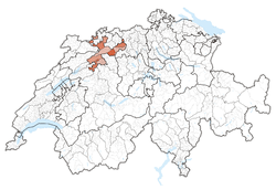 Location in Switzerland | ||
|
Map of Solothurn 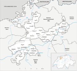 | ||
| Coordinates: 47°9′N 7°38′E / 47.150°N 7.633°ECoordinates: 47°9′N 7°38′E / 47.150°N 7.633°E | ||
| Capital | Solothurn | |
| Largest City | Olten | |
| Subdivisions | 122 municipalities, 10 districts | |
| Government | ||
| • Executive | Regierungsrat (5) | |
| • Legislative | Kantonsrat (100) | |
| Area[1] | ||
| • Total | 790.45 km2 (305.19 sq mi) | |
| Population (12/2016)[2] | ||
| • Total | 269,441 | |
| • Density | 340/km2 (880/sq mi) | |
| ISO 3166 code | CH-SO | |
| Highest point | 1,445 m (4,741 ft): Hasenmatt | |
| Lowest point | 277 m (909 ft): Birs at the cantonal border in Dornach | |
| Joined | 1481 | |
| Languages | German | |
| Website | SO.ch | |
The canton of Solothurn, also canton of Soleure (German: ![]()
History
Foundation of the village of Salodurum in the time of the Roman emperor Tiberius. The territory of the canton comprises land acquired by the former town, mainly in the middle age. For that reason the shape of the canton is irregular and includes two exclaves along the French border, separated from the rest of the canton by Basel-Land, which form separate districts of the canton. In 1481, the canton became a member of the military alliance of the former Swiss confederation. At the end of the Reformation, Solothurn maintained its Catholic religion. Between 1798 and 1803 the canton was part of the Helvetic Republic. In 1803 Solothurn was one of the 19 Swiss cantons that were reconstituted by Napoleon (Mediation). In 1830, the population rebelled against the aristocratic regime and the canton became definitely liberal-democratic. Even though the population was strictly Roman Catholic, Solothurn did not join the Catholic separatist movement (Sonderbund) in 1845-7. Similarly, the federal constitutions of 1848 and 1874 were approved. The current constitution of the canton dates from 1987.
Geography
The canton is located in the north-west of Switzerland. To the west and south lie the cantons of Jura and Bern, to the east is Aargau. To the north the canton is bounded by the canton of Basel-Landschaft. Parts of two of the districts are exclaves and are located along the border of France (Grand Est). The lands are drained by the Aare river and its tributaries. The landscape is mostly flat, but it includes the foothills of the Jura massif. Part of this, the massif of the Weissenstein, overlooks Solothurn and the Mitteland from the north and has views of the Bernese Alps. The flat lands are a plain created by the Aare river. The total area of the canton is 791 km².
Political subdivisions
Districts

From 2005, Solothurn's ten districts are merged pairwise into five electoral districts, termed Amtei. From 2005, the districts have only a statistical significance.
- Bucheggberg, Amtei Wasseramt-Bucheggberg
- Dorneck, Amtei Dorneck-Thierstein (unofficially Schwarzbubenland)
- Gäu, Amtei Thal-Gäu
- Gösgen, Amtei Olten-Gösgen (unofficially Niederamt)
- Lebern, Amtei Solothurn-Lebern
- Olten, Amtei Olten-Gösgen
- Solothurn, Amtei Solothurn-Lebern
- Thal, Amtei Thal-Gäu
- Thierstein, Amtei Dorneck-Thierstein
- Wasseramt, Amtei Wasseramt-Bucheggberg
Municipalities
There are 125 municipalities in the canton (As of 2009).[3]
Demographics
The population is mostly German-speaking. About 44% of the population are Roman Catholic, with most of the remainder being Protestants (31% as of 2000).[4] The population of the canton (as of 31 December 2016) is 269,441.[2] As of 2007, the population included 46,898 foreigners, or about 18.7% of the total population.[5]
Economy
Up to the 19th century agriculture was the main economic activity in the canton. Agriculture is still of importance, but manufacturing and the service industry are now more significant. The industries of the canton are specialized in watches, jewellery, textiles, paper, cement and auto parts. Until recently the manufacturing of shoes was an important economic activity, but global competition thought that the Swiss canton was not competitive enough.
The canton is home to the Gösgen Nuclear Power Plant near Däniken which started operation in 1979.
Politics
Federal election results
| Percentage of the total vote per party in the canton in the Federal Elections 1971-2015[6] | ||||||||||||||
|---|---|---|---|---|---|---|---|---|---|---|---|---|---|---|
| Party | Ideology | 1971 | 1975 | 1979 | 1983 | 1987 | 1991 | 1995 | 1999 | 2003 | 2007 | 2011 | 2015 | |
| FDP.The Liberalsa | Classical liberalism | 34.3 | 38.7 | 39.0 | 37.2 | 36.3 | 32.8 | 25.4 | 25.4 | 24.0 | 21.0 | 18.4 | 21.2 | |
| CVP/PDC/PPD/PCD | Christian democracy | 27.7 | 26.0 | 27.6 | 26.7 | 25.1 | 22.2 | 21.5 | 21.4 | 21.0 | 20.4 | 17.9 | 14.8 | |
| SP/PS | Social democracy | 26.3 | 31.4 | 28.4 | 27.8 | 22.3 | 19.8 | 24.2 | 27.2 | 25.4 | 19.5 | 18.3 | 20.0 | |
| SVP/UDC | Swiss nationalism | * b | * | * | * | * | * | 6.7 | 18.6 | 22.5 | 27.1 | 24.3 | 28.8 | |
| Ring of Independents | Social liberalism | 7.2 | * | * | 4.0 | 3.5 | 2.9 | 1.6 | * | * | * | * | * | |
| EVP/PEV | Christian democracy | * | * | * | * | * | 1.2 | * | * | 1.2 | 1.8 | 1.5 | 1.2 | |
| GLP/PVL | Green liberalism | * | * | * | * | * | * | * | * | * | * | 5.0 | 3.5 | |
| BDP/PBD | Conservatism | * | * | * | * | * | * | * | * | * | * | 4.4 | 3.4 | |
| PdA/PST-POP/PC/PSL | Socialism | * | * | 1.0 | * | 0.3 | * | * | * | * | * | * | * | |
| POCH | Progressivism | * | 3.4 | 4.1 | 3.5 | * | * | * | * | * | * | * | * | |
| GPS/PES | Green politics | * | * | * | * | * | 7.3 | 5.8 | 4.9 | 6.0 | 10.0 | 7.5 | 5.6 | |
| SD/DS | National conservatism | 4.6 | * | * | * | * | * | 2.8 | * | * | 0.4 | 0.4 | * | |
| EDU/UDF | Christian right | * | * | * | * | * | * | * | * | * | * | 0.5 | 0.5 | |
| FPS/PSL | Right-wing populism | * | * | * | * | 4.9 | 9.1 | 10.6 | 1.3 | * | * | * | * | |
| Other | * | 0.6 | * | 0.9 | 7.5 | 4.7 | 1.3 | 1.3 | * | * | 2.3 | 1.0 | ||
| Voter participation % | 64.2 | 64.1 | 56.9 | 60.7 | 60.8 | 56.1 | 48.3 | 50.0 | 47.4 | 50.7 | 51.7 | 50.2 | ||
Transport
The canton has good connections with other parts of Switzerland, both by rail and by road. There is a railway junction at Olten with direct trains to Geneva, Zurich, Basel and the Ticino via Lucerne.
Notes and references
- ↑ Arealstatistik Land Cover - Kantone und Grossregionen nach 6 Hauptbereichen accessed 27 October 2017
- 1 2 Swiss Federal Statistical Office - STAT-TAB, online database – Ständige und nichtständige Wohnbevölkerung nach institutionellen Gliederungen, Geburtsort und Staatsangehörigkeit (in German) accessed 30 August 2017
- ↑ "Liste officielle des communes de la Suisse - 01.01.2008". Office fédéral de la statistique. Archived from the original on 12 June 2009. Retrieved 15 December 2008.
- ↑ Federal Department of Statistics (2004). "Wohnbevölkerung nach Religion". Archived from the original (Interactive Map) on 2016-09-24. Retrieved 2009-01-15.
- ↑ Federal Department of Statistics (2008). "Ständige Wohnbevölkerung nach Staatsangehörigkeit, Geschlecht und Kantonen". Archived from the original (Microsoft Excel) on December 15, 2008. Retrieved November 5, 2008.
- ↑ Nationalratswahlen: Stärke der Parteien nach Kantonen (Schweiz = 100%) (Report). Swiss Federal Statistical Office. 2015. Archived from the original on 2016-08-02. Retrieved 2016-08-05.
External links
| Wikimedia Commons has media related to Canton of Solothurn. |
- Official site (in German)
- Official statistics
|
| Authority control |
|---|