Doubs (river)
| Doubs | |
|---|---|
 The Doubs just before Besançon | |
| Native name | Le Doubs |
| Other name(s) | German: Dub |
| Country | France, Switzerland |
| Physical characteristics | |
| Main source |
Mouthe, Jura mountains 946 m (3,104 ft) 46°42′17″N 6°12′34″E / 46.70472°N 6.20944°E |
| River mouth |
Saône 175 m (574 ft) 46°54′3″N 5°1′27″E / 46.90083°N 5.02417°ECoordinates: 46°54′3″N 5°1′27″E / 46.90083°N 5.02417°E |
| Length | 453 kilometres (281 mi) |
| Discharge |
|
| Basin features | |
| Progression | Saône→ Rhône→ Mediterranean Sea |
| Basin size | 7,500 km2 (2,900 sq mi) |
| Tributaries | |
| Lakes | Lake Saint-Point, Lake of Brenets |
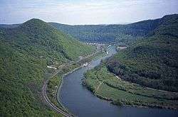
The Doubs (French: Le Doubs, French pronunciation: [du], German: Dub) is a 453 kilometres (281 mi) long river in eastern France and western Switzerland, left tributary of the Saône. Its source is near Mouthe in the western Jura mountains, at an altitude of 946 m. It is the tenth longest French river in France.
Course
From its source in Mouthe it flows northeast, more or less along the French-Swiss border (forming the border for approx. 40 km). Near Montbéliard it turns southwest, until it flows into the river Saône in Verdun-sur-le-Doubs, approx. 20 km northeast of Chalon-sur-Saône. Its entire course resembles an inverted letter U, with the northeastern corner the only point at which the Doubs flows into Switzerland as far as Saint-Ursanne. In Switzerland it traverses the cantons Jura and Neuchâtel.
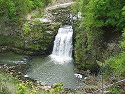
The waterfall known as the Saut du Doubs is located on the French-Swiss border.
.jpg)
The Doubs flows through the following Departments of France, Cantons of Switzerland, and cities:
- Doubs (F): Pontarlier
- Neuchâtel (CH)
- Jura (CH): Saint-Ursanne
- Doubs (F): Montbéliard, Besançon
- Jura (F): Dole
- Saône-et-Loire (F): Verdun-sur-le-Doubs
Tributaries include:
The river forms several lakes:
- Lac des Brenets (elevation 750 m)
- Lac de Moron (elevation 716 m)
- Lac de Biaufond (elevation 610 m)

Floods and Seasonal Variation
The rate of flow of the Doubs is very seasonally variable. The flooding season can stretch from September to May, with floods being occasioned either by heavy rains or by quick melting of snow from the Jura mountains. At its mouth, the discharge rate can vary from as low as 20 m³/s to over 1000 m³/s during floods.
In Besançon, the largest floods have been in 1852 (8.50 m), in 1896 (7.96 m) and in 1910. There have also been many lesser floods more recently.
Hydroelectricity

As a mountain river with substantial discharge, the Doubs has been used for electricity generation. Among several hydroelectric stations, the most important are the Dam of Châtelot, 74 metres tall, and the Dam of Refrain, 66.5 metres tall.
See also
References
| Wikimedia Commons has media related to Doubs River. |
| Wikisource has the text of the 1911 Encyclopædia Britannica article Doubs (river). |