Allaine (river)
| Allaine | |
|---|---|
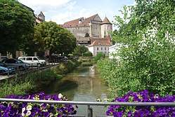 The Allaine in Porrentruy | |
| Native name | l'Allaine (f) |
| Other name(s) | l'Allan (m, lower course) |
| Countries | Switzerland, France |
| Physical characteristics | |
| Main source |
Above Charmoille near Porrentruy in the Swiss Jura mountains 598 m (1,962 ft) 47°25′46″N 7°13′49″E / 47.42939°N 7.23038°E |
| River mouth |
Doubs near Montbéliard 335 m (1,099 ft) 47°28′43″N 6°45′35″E / 47.4785°N 6.7597°ECoordinates: 47°28′43″N 6°45′35″E / 47.4785°N 6.7597°E |
| Length | 65 km (40 mi) |
| Basin features | |
| Progression | Doubs→ Saône→ Rhône→ Mediterranean Sea |
| Basin size | 322 km2 (124 sq mi) |
The Allaine (French: l'Allaine (f), in its lower course l'Allan (m)) is a 65 km long river in northwestern Switzerland and eastern France. Its source is above the village Charmoille, in the Swiss Jura mountains. Downstream from its confluence with the Bourbeuse and the Canal du Rhône au Rhin, near Méziré, it is called the Allan. It is a right tributary of the Doubs, which it joins a few km downstream from Montbéliard, where it takes the Savoureuse with it, a river with its sources in the southern Vosges.[1]
The Allaine/Allan flows through the following cantons, departments and towns:
- Canton of Jura (CH): Charmoille, Porrentruy
- Territoire de Belfort (F): Delle, Grandvillars
- Doubs (F): Montbéliard
References
| Wikimedia Commons has media related to Allaine. |
This article is issued from
Wikipedia.
The text is licensed under Creative Commons - Attribution - Sharealike.
Additional terms may apply for the media files.