Dorseyville, Maryland
| Dorseyville, Maryland | |
|---|---|
| Unincorporated community | |
 Dorseyville | |
| Coordinates: 39°15′40″N 77°02′13″W / 39.26111°N 77.03694°WCoordinates: 39°15′40″N 77°02′13″W / 39.26111°N 77.03694°W | |
| Country |
|
| State |
|
| County |
|
| Time zone | UTC-5 (Eastern (EST)) |
| • Summer (DST) | UTC-4 (EDT) |
Dorseyville is an unincorporated community in Howard County, Maryland, United States. It is considered part of the modern Glenwood area. The village was situating along a fork in the rolling road that would service Annapolis, Maryland or Tridelphia, Maryland. A stone dam, named Dorsey's Mill Dam was situated on the Cattail Creek here before being washed out.[1]
See also
References
- ↑ Howard's Roads to the Past. Howard County Sesquicentennial Celebration Committee, 2001. 2001. p. 91.
Municipalities and communities of Howard County, Maryland, United States | ||
|---|---|---|
| CDPs | 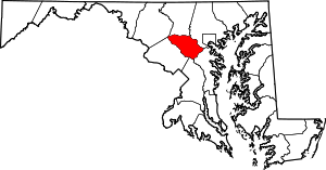 | |
| Villages | ||
| Unincorporated communities |
| |
| Footnotes | ‡This populated place also has portions in an adjacent county or counties | |
This article is issued from
Wikipedia.
The text is licensed under Creative Commons - Attribution - Sharealike.
Additional terms may apply for the media files.