Doré Lake
| Doré Lake | |
|---|---|
 | |
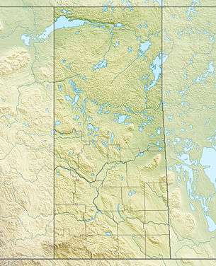 Doré Lake Location of Doré Lake in Saskatchewan | |
| Location | Saskatchewan |
| Coordinates | 54°46′N 107°18′W / 54.767°N 107.300°WCoordinates: 54°46′N 107°18′W / 54.767°N 107.300°W |
| Primary outflows | Doré River to the Beaver River |
| Catchment area | 2,435 km2 (940 sq mi) |
| Basin countries | Canada |
| Surface area | 640 km2 (250 sq mi) |
| Average depth | 10.9 m (36 ft) |
| Max. depth | 20.4 m (67 ft) |
| Water volume | 6.68 km3 (5,420,000 acre⋅ft) |
| Residence time | 175 years |
| Shore length1 | 195 km (121 mi) |
| Surface elevation | 459 m (1,506 ft) |
| References | [1][2] |
| 1 Shore length is not a well-defined measure. | |
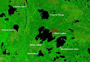
Doré Lake is a lake of Saskatchewan in the basin of the Beaver River (Canada). The northern village of Dore Lake is located on South Bay and is accessed by Highway 924. Big Island, Iskwasoo and Burnt are islands in the north section while Smith Island is to the west. The Doré River flows into the Beaver River from the west side of the lake.[3][4] Doré is the Canadian French term for walleye.
See also
- List of lakes in Saskatchewan
- Lake Doré in Ontario
References
- ↑ "Principal lakes, elevation and area, by province and territory". Statistics Canada. 2005-02-02. Retrieved 2015-03-11.
- ↑ "World Lake Database (Dore Lake)". Retrieved 2014-08-29.
- ↑ "Natural Resources Canada-Canadian Geographical Names (Doré Lake)". Retrieved 2014-08-29.
- ↑ "Atlas of Canada Toporama". Retrieved 2014-08-29.
External links
This article is issued from
Wikipedia.
The text is licensed under Creative Commons - Attribution - Sharealike.
Additional terms may apply for the media files.