Doom Island
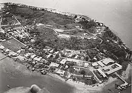 Doom in 1955 | |
| Geography | |
|---|---|
| Coordinates | 0°53′13″S 131°14′10″E / 0.88694°S 131.23611°ECoordinates: 0°53′13″S 131°14′10″E / 0.88694°S 131.23611°E |
| Administration | |
| Province | West Papua |
| City | Sorong |
| District | Sorong Islands |
Doom Island (Indonesian: Pulau Doom, pronounced "Dom"[1]) is a small island in West Papua, Indonesia. It is administratively part of the city of Sorong, specifically the Sorong Islands district.
The island served as an administrative center of Dutch administration in West Papua, and continued to become the core of Sorong for some time before the city grew in mainland Papua.
Geography and administration
The island is located around 3 kilometres (1.9 mi) away from mainland Sorong.[2] It has a perimeter of around 4.5 kilometres (2.8 mi).[3]
The island is part of two administrative villages (kelurahan): West and East Doom. The two villages also include other small islands close to Sorong. As of 2016, the two villages have a population of 9,143.[4]
History
Prior to European colonization, the island had been part of the Sultanate of Tidore.[5]
First appearing in Dutch records by 1863 through a study by Heinrich Agathon Bernstein, the island was colonized by the Dutch early in the establishment of Netherlands New Guinea, with a colonial post being officially established in 1906 with a Minahasan being appointed as the head.[3][6] The island later served as an administrative post, with multiple office buildings, a prison, and a "pleasure building" being constructed on the island.[7] A diesel-powered electrical generator was installed on the island to supply electricity for the buildings.[8] The island acted as an administrative center for the onderafdeling of Sorong between 1935 and 1950-1952.[3]
During the Second World War, Japanese forces occupied and fortified the island, building a network of tunnels and bunkers.[9] The island was attacked by American and Australian aircraft throughout the war.[10][11]
Following the war, a fishing station was briefly established on the island before it was moved to Manokwari.[12] After the takeover of West Papua by Indonesia, growth of Sorong forced the movement of the city to the mainland around 1965,[1] although the island initially remained developed relative to mainland Sorong until the latter grew, with Doom being called the "star island" in the 1970s-80s due to its relatively bright lights.[13]
Access and facilities
Due to its short distance from Sorong, Doom is reachable by boat within 10 minutes from the mainland.[9] The island has a reverse osmosis seawater processing facility, capable of processing 9,000 liters per hour.[14]
There is a highschool on the island, which used to be a Dutch prison complex,[15] and a football field.[3]
References
- 1 2 Pickell, David (2013). Indonesian New Guinea Adventure Guide: WEST PAPUA / IRIAN JAYA. Tuttle Publishing. ISBN 9781462909254. Retrieved 18 September 2018.
- ↑ "Nostalgia Sejarah Pulau Doom". indonesiakaya.com (in Indonesian). Retrieved 18 September 2018.
- 1 2 3 4 Gentong, Aryo Wisanggeni (4 August 2008). "Menelusuri Kota Tua ala Belanda". KOMPAS (in Indonesian). Retrieved 18 September 2018.
- ↑ "Sorong Islands District in Numbers". sorongkota.bps.go.id. Retrieved 18 September 2018.
- ↑ Silaban, M. H. (1963). Irian Barat (in Indonesian). Pustaka Sri. p. 17.
Kesultanan Tidore kelak menguasai daerah2 di Irian Barat, antara lain pulau Doom, Sorong
- ↑ Indonesia Reports. Indonesia Publications. 1986. p. 49. Retrieved 18 September 2018.
- ↑ Shafa, Faela (19 April 2016). "Pulau Doom, Jejak Pemerintahan Pertama Belanda di Papua". detikTravel (in Indonesian). Retrieved 18 September 2018.
- ↑ "Jejak Belanda yang Hilang di Pulau Doom, Sorong". detikTravel (in Indonesian). 7 October 2013. Retrieved 18 September 2018.
- 1 2 "Pulau Doom Wisata Sejarah di Kota Sorong". Antara News (in Indonesian). 1 January 2018. Retrieved 18 September 2018.
- ↑ "Month by month chronology of the 5th AF". kensmen.com. Retrieved 18 September 2018.
- ↑ "No. 15 Squadron". awm.gov.au. Retrieved 18 September 2018.
- ↑ Palomares, Maria Lourdes D; Heymans, Johanna J. (2006). "Historical ecology of the Raja Ampat Archipelago, Papua Province, Indonesia". doi:10.14288/1.0074771. Retrieved 18 September 2018.
- ↑ "Doom Island, the Origin of Sorong". Tempo. 8 April 2015. Retrieved 18 September 2018.
- ↑ Solo, Martinus (17 October 2016). "Pulau Doom Olah Air Laut Jadi Air Minum". Media Indonesia (in Indonesian). Retrieved 18 September 2018.
- ↑ Yustiana, Kurnia (12 November 2015). "Mengintip Sekolah di Sorong yang Dulunya Penjara Belanda". detikTravel (in Indonesian). Retrieved 18 September 2018.