Donji Kokoti
| Donji Kokoti Доњи Кокоти | |
|---|---|
| Suburb | |
 Donji Kokoti | |
| Coordinates: 42°24′02″N 19°11′30″E / 42.40056°N 19.19167°E | |
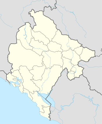
| Country | Montenegro |
| Municipality | Podgorica Municipality |
| Elevation | 72 ft (22 m) |
| Population (2011) | |
| • Total | 1,080 |
| Time zone | UTC+1 (CET) |
| • Summer (DST) | UTC+2 (CEST) |
Donji Kokoti is a suburb located five kilometers of Podgorica, Montenegro. According to the 2011 census, it had a population of 1,080, the majority of which identified as Montenegrins. It is on the banks of rivers Morača and Sitnica.
History and geography
Donji Kokoti are a part of historical region Lješkopolje, situated in southwest Podgorica. Settlement is built on a plain above the riverbanks.
Located near the capital Podgorica, until the end of World War II, Donji Kokoti were a village with about a hundred households. Since then, population of settlement is continuously growing and on the last census (2011), for the first time in history, number of inhabitants is over 1,000.
Donji Kokoti are situated on a plain between two rivers, with neighbouring settlements Donja Gorica on the east and north, Farmaci on the west, Botun on the south.
Today, Donji Kokoti are a suburban settlement from the left side of M-2.3 road, one of most important traffic links in Montenegro. During the 2018, started a construction of new bridge on Morača river, from Donji Kokoti to Podgorica Airport and main road to Montenegrin riviera.[1]
Settlement is a part of Local community "Lješkopolje", which is a part of Capital City Podgorica.
Economy
As it is situated near the major M-2.3 road, in Donji Kokoti are seat of few construction companies, import companies, furniture and car-factory salons.
Still, the main activity of local residents is agriculture, especially producing of watermelons, grapes, other fruit and tomatoes. In the past, during the existence of SFR Yugoslavia, Donji Kokoti with the nearby settlements were the seat of collective agriculture plantations (so-called zadruga).
Fishing on Sitnica and Morača rivers is also one of the main activities of local residents, especially during the winter and spring months.
Demographics
| Historical population | ||
|---|---|---|
| Year | Pop. | ±% |
| 1948 | 303[2] | — |
| 1953 | 333 | +9.9% |
| 1961 | 405 | +21.6% |
| 1971 | 421 | +4.0% |
| 1981 | 523 | +24.2% |
| 1991 | 581 | +11.1% |
| 2003 | 772 | +32.9% |
| 2011 | 1,080 | +39.9% |
Donji Kokoti are among the Podgorica suburban settlements with continuous population growth. According to 2011 census, it had a population of 1,080.
According to 2011 census,[3] he majority of Donji Kokoti citizens are Montenegrins. According to 2011 census, there was a 62 percent of Montenegrin population and 28 percent of Serbs. By religious views, dominant majority of population are Orthodox Christians (88.70%).
| Nationality (2011) | Number | Percentage |
|---|---|---|
| Montenegrins | 667 | 61.76% |
| Serbs | 304 | 28.14% |
| Albanians | 9 | 0.84% |
| others | 30 | 2.78% |
| undeclared | 70 | 6.48% |
Sports
Facilities
There are numerous sports facilities in Donji Kokoti: two football pitches (FK Napredak, FK Bubamara), four tennis courts (TK As) and one basketball hall (so-called House of basketball), training ground of KK Budućnost and ŽKK Budućnost.
Clubs
Most known sports team from Donji Kokoti was FK Napredak which participated in lower Montenegrin football leagues from 1971 to 1995. Another, also inactive football club, named Bubamara, plays in the leagues for young players. Football team which today unites all the region of Lješkopolje is OFK Mladost Lješkopolje. Donji Kokoti are Podgorica's center of tennis and home to Tennis club As.
WTA tournament
Every year, Donji Kokoti are home of most important international tennis tournament in Montenegro – WTA Podgorica,[4] also known as a Royal Cup NLB Montenegro. First edition of $25,000 tournament was held on 2004. Initiated as a tournament of women tennis players from former Yugoslavia, WTA Podgorica soon became a competition with participation of numerous players from Western Europe and Americas.
See also
References
- ↑ http://podgorica.me/2018/05/23/potpisan-ugovor-za-novi-most-na-moraci-radovi-na-jugozapadnoj-obilaznici-mogu-da-pocnu/
- ↑ Knjiga 9, Stanovništvo, uporedni pregled broja stanovnika 1948, 1953, 1961, 1971, 1981, 1991, 2003, podaci po naseljima, Republički zavod za statistiku, Podgorica, septembar 2005, COBISS-ID 8764176
- ↑ "Montenegrin census 2011, official data".
- ↑ "WTA Podgorica database".
Coordinates: 42°24′N 19°11′E / 42.400°N 19.183°E
| City municipalities |  | |
|---|---|---|
| Neighborhoods | ||
| Municipality settlements | List
| |
| Geography | ||
| Landmarks | ||
| Culture | ||
| Sports venues | ||
| Sport clubs | ||
| Events | ||
| Education | ||
| Media | ||
| Shopping malls | ||
| Companies | ||
| Transportation | ||