Doai Station
Doai Station 土合駅 | |
|---|---|
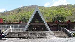 Doai Station entrance in April 2016 | |
| Location |
218-2 Yubiso, Minakami-machi, Tone-gun, Gunma-ken Japan |
| Operated by |
|
| Line(s) | ■ Joetsu Line |
| Distance | 69.3 km from Takasaki |
| Platforms | 2 side platforms |
| Tracks | 2 |
| Construction | |
| Depth | 70 m |
| Platform levels | 2 |
| History | |
| Opened | 19 December 1936 |
| Traffic | |
| Passengers (FY2011) | 22 daily |
| Location | |
 Doai Station Location within Japan | |
Doai Station (土合駅 Doai Eki) is a railway station on the Joetsu Line in Minakami, Gunma, Japan, operated by the East Japan Railway Company (JR East).
Lines
Doai Station is served by the Joetsu Line, and lies 69.3 km (43.1 mi) from the starting point of the line at Takasaki.
Station layout
Doai Station is unusual in that it has two single side platforms, one of which is elevated, and the other is located underground within the Shin-Shimizu Tunnel. The station is unattended. The underground platform for the northbound trains (to Echigo-Yuzawa and Nagaoka) is located 70 metres (230 ft) underground, in the middle of the 13,490-metre (44,260 ft) long Shin-Shimizu Tunnel. It only reachable by stairs, as there are no elevators or escalators.[1] It takes 10 minutes to walk the 486 steps from the ticket gate to the platform. The above-ground platform for the southbound trains (to Minakami) is at ground level. The climb up the steps from the underground platform features at the start of the novel, NHK dramatization and movie versions of Climber's High by Hideo Yokoyama.
Platforms
| underground | ■ Joetsu Line | for Echigo-Yuzawa, Urasa, Nagaoka, and Niigata |
| aboveground | ■ Joetsu Line | for Minakami, Takasaki, and Ueno |
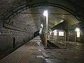 The underground platform
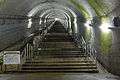 The bottom of the steps at the underground platform
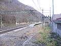 The ground-level platform
Adjacent stations
| « | Service | » | ||
|---|---|---|---|---|
| Joetsu Line | ||||
| Yubiso | Local | Tsuchitaru | ||
History
The station opened on 19 December 1936.[2] With the privatization of Japanese National Railways (JNR) on 1 April 1987, the station came under the control of JR East.[2]
Surrounding area
- Mount Tanigawa (one of the "100 famous mountains in Japan")
- National Route 291
See also
References
- ↑ "Doai Station: Journey to Japan's Deepest Station". Ridgeline Images. 31 July 2016. Retrieved 30 January 2018.
- 1 2 Ishino, Tetsu, ed. (1998). 停車場変遷大辞典 国鉄・JR編 [Station Transition Directory - JNR/JR] (in Japanese). II. Japan: JTB. p. 452. ISBN 4-533-02980-9.
External links
| Wikimedia Commons has media related to Doai Station. |
- Station information (JR East) (in Japanese)
Coordinates: 36°49′52.8″N 138°58′1.6″E / 36.831333°N 138.967111°E