Districts and sub-districts of the United States Virgin Islands
| Districts of the U.S. Virgin Islands | |
|---|---|
 | |
| Category | Federal Unit |
| Location | United States Virgin Islands |
| Number |
2 (Administrative) 3 (U.S. Census Bureau) |
| Populations | 4,170 (Saint John) – 51,634 (Saint Thomas (U.S. Census Bureau divisions) |
| Areas | 19.61 square miles (50.8 km2) (Saint John) – 82.88 square miles (214.7 km2) (Saint Croix) (U.S. Census Bureau divisions) |
| Government | District government |
| Subdivisions | Subdistrict |
 |
|---|
| This article is part of a series on the politics and government of the United States Virgin Islands |
|
Legislature
|
|
Judiciary
|
|
Divisions |
|
The United States Virgin Islands (pop. 106,405[1]) are administratively divided into 2 districts, which are subdivided into 20 subdistricts. These are further divided into quarters and estates.
The districts are:
Saint Thomas and Saint John together form a single district, while Saint Croix is a separate district.[2][3][4] However, the U.S. Census Bureau counts each of the 3 main islands (Saint Thomas, Saint John and Saint Croix) as separate statistical entities, in spite of the fact that there are 2 districts.[5][6][7]
The U.S. Virgin Islands legislature has 15 seats: 7 seats are for the Saint Croix District, 7 seats are for the Saint Thomas and Saint John District, and one seat is for someone who must live in Saint John.[3]
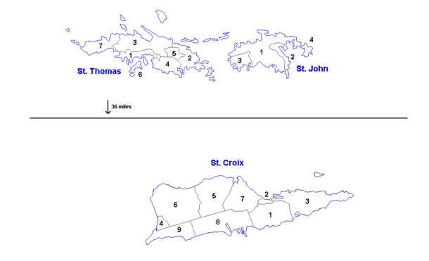
Below is the U.S. Census Bureau's model, in which each of the 3 main islands is counted as a separate district:
The subdistricts of the Saint Croix census district (pop. 50,601[1]) are:
- Anna's Hope Village (pop. 4,041[1])
- Christiansted (pop. 2,626[1])
- Christiansted town (pop. 2,433[1])
- East End (pop. 2,453 [1])
- Frederiksted (pop. 3,091 [1])
- Frederiksted town (pop. 859 [1])
- Northcentral (pop. 4,977[1])
- Northwest (pop. 4,863[1])
- Sion Farm (pop. 13,003[1])
- Southcentral (pop. 8,049[1])
- Southwest (pop. 7,498[1])
The sub-districts of the Saint Thomas census district (pop. 51,634[1]) are:
- Charlotte Amalie (pop. 18,481[1])
- Charlotte Amalie town (pop. 10,354[1])
- East End (pop. 8,403[1])
- Northside (pop. 10,049[1])
- Southside (pop. 5,411[1])
- Tutu (pop. 6,867[1])
- Water Island (pop. 182[1])
- West End (pop. 2,241[1])
The sub-districts of the Saint John census district (pop. 4,170[1]) are:
The county-level FIPS codes for the U.S. Virgin islands are:[5][7]
- Saint Croix — 78010
- Saint John — 78020
- Saint Thomas — 78030
Each island is treated as a county-equivalent.[5][7]
See also
References
- 1 2 3 4 5 6 7 8 9 10 11 12 13 14 15 16 17 18 19 20 21 22 23 24 25 26 27 2010 Census U.S. Virgin Islands Archived 2012-10-02 at the Wayback Machine. Also available at https://www.census.gov/2010census/news/xls/cb11cn180_vi.xls
- ↑ http://www.legvi.org/senators/st-thomasst-john/senator-marvin-a-blyden/ legvi.org. Senator Marvin A. Blyden. Retrieved July 7, 2018.
- 1 2 http://www.legvi.org/history/ Legvi.org. History. Retrieved July 7, 2018.
- ↑ https://www.usgs.gov/faqs/how-many-counties-are-there-united-states USGS. How many counties are there in the United States? Retrieved July 7, 2018.
- 1 2 3 https://www.census.gov/geo/reference/codes/cou.html 2010 FIPS Codes for Counties and County Equivalent Entities. Census.gov. Retrieved July 7, 2018.
- ↑ https://www2.census.gov/geo/pdfs/reference/GARM/Ch4GARM.pdf States, Counties, and Statistically Equivalent Entities (Chapter 4). Census.gov. Retrieved July 7, 2018.
- 1 2 3 http://www.statoids.com/uvi.html Districts of the United States Virgin Islands. Statoids.com. Retrieved July 7, 2018.
External links
Charlotte Amalie (capital) | |
| Topics |
|
| Government | |
| Cities | |
| Islands | |
| Parks | |
Administrative divisions of the Americas | ||
|---|---|---|
| ||
| Sovereign states |
| .svg.png) |
| ||