Digerronden
| Digerronden | |
|---|---|
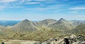 Digerronden to the left. Midtronden in the centre and Høgronden to the right. | |
| Highest point | |
| Elevation | 2,015 m (6,611 ft) |
| Prominence | 180 m (590 ft) [1] |
| Coordinates | 61°57′12″N 9°49′53″E / 61.95333°N 9.83139°ECoordinates: 61°57′12″N 9°49′53″E / 61.95333°N 9.83139°E |
| Geography | |
| Location | Dovre, Oppland, Norway |
| Parent range | Rondane |
| Topo map | 1718 I Rondane |
Digerronden is one of the ten mountains in Rondane National Park over 2,000 m, and lies in the municipality Dovre in Oppland, Norway. It has a characteristic pyramidal shape.
The name
The first element is diger 'huge, enormous', for the last element see Rondane.
See also
References
This article is issued from
Wikipedia.
The text is licensed under Creative Commons - Attribution - Sharealike.
Additional terms may apply for the media files.