Dickens, Nebraska
| Dickens, Nebraska | |
|---|---|
| Unincorporated community | |
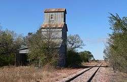 Abandoned grain elevator in Dickens | |
 Dickens, Nebraska Location within the state of Nebraska | |
| Coordinates: 40°49′34″N 100°59′35″W / 40.82611°N 100.99306°WCoordinates: 40°49′34″N 100°59′35″W / 40.82611°N 100.99306°W | |
| Country | United States |
| State | Nebraska |
| County | Lincoln |
| Elevation | 3,136 ft (956 m) |
| Time zone | UTC-6 (Central (CST)) |
| • Summer (DST) | UTC-5 (CDT) |
| ZIP codes | 69132 |
| GNIS feature ID | 835287 |
Dickens is an unincorporated community in southwestern Lincoln County, Nebraska, United States. It lies along Nebraska Highway 23 southwest of the city of North Platte, the county seat of Lincoln County.[1] Its elevation is 3,136 feet (956 m). The community is named for Charles Dickens.[2] Although Dickens is unincorporated, it has a post office, with the ZIP code of 69132.[3]
History
Dickens had its start in the 1880s by the building of the Chicago, Burlington and Quincy Railroad through that territory.[4]
References
- ↑ Rand McNally. The Road Atlas '08. Chicago: Rand McNally, 2008, p. 62.
- ↑ U.S. Geological Survey Geographic Names Information System: Dickens, Nebraska, Geographic Names Information System, 1979-03-09. Accessed 2008-04-26.
- ↑ "Archived copy". Archived from the original on 2010-11-23. Retrieved 2007-01-03. USPS Zip Code Lookup
- ↑ "Dickens, Lincoln County". Center for Advanced Land Management Information Technologies. University of Nebraska. Retrieved 19 August 2014.
Municipalities and communities of Lincoln County, Nebraska, United States | ||
|---|---|---|
| City | ||
| Villages | ||
| Unincorporated communities | ||
This article is issued from
Wikipedia.
The text is licensed under Creative Commons - Attribution - Sharealike.
Additional terms may apply for the media files.