Dhola, Nepal
| Dhola, Nepal ढोला | |
|---|---|
| Village development committee | |
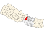
 Dhola, Nepal Location in Nepal | |
| Coordinates: 27°55′N 84°50′E / 27.92°N 84.83°ECoordinates: 27°55′N 84°50′E / 27.92°N 84.83°E | |
| Country |
|
| Zone | Bagmati Zone |
| District | Dhading District |
| Population (2011) | |
| • Total | 4,033 |
| • Religions | Hindu |
| Time zone | UTC+5:45 (Nepal Time) |
Dhola, Nepal is a village development committee in Dhading District in the Bagmati Zone of central Nepal. It is situated high up the Himalayas in the Annapurna and Manaslu Mountain range in the mid-western Nepal at an altitude of 1210 m above the sea level. At the time of the 2011 Nepal census it had a population of 4,033 and had 998 houses in it. Where total population of Male and Female are 1,772 and 2,261 respectively.
References
Headquarter: Dhading Besi | ||
| Gaupalika |
|  |
| Municipalities |
| |
This article is issued from
Wikipedia.
The text is licensed under Creative Commons - Attribution - Sharealike.
Additional terms may apply for the media files.