Derby, North West
| Derby | |
|---|---|
 | |
 Derby  Derby Derby (South Africa)  Derby Derby (Africa) | |
| Coordinates: 25°54′S 27°02′E / 25.900°S 27.033°ECoordinates: 25°54′S 27°02′E / 25.900°S 27.033°E | |
| Country | South Africa |
| Province | North West |
| District | Bojanala Platinum |
| Municipality | Kgetlengrivier |
| Area[1] | |
| • Total | 1.78 km2 (0.69 sq mi) |
| Population (2011)[1] | |
| • Total | 3,471 |
| • Density | 2,000/km2 (5,100/sq mi) |
| Racial makeup (2011)[1] | |
| • Black African | 85.1% |
| • Coloured | 0.7% |
| • Indian/Asian | 1.4% |
| • White | 12.8% |
| First languages (2011)[1] | |
| • Tswana | 76.3% |
| • Afrikaans | 13.7% |
| • English | 4.0% |
| • Zulu | 1.5% |
| • Other | 4.5% |
| Time zone | UTC+2 (SAST) |
| PO box | 0347 |
| Area code | 014 |
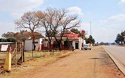
Derby is a small town situated in North West Province of South Africa that was named after the British Secretary of State Lord Derby. Derby began as a refuge for destitute people.
Village 117 km west-north-west of Johannesburg, 60 km south-west of Rustenburg and 17 km east of Koster. Laid out on portions of the farms Rietfontein and Vlakfontein, it was named after Lord Derby, British Secretary of State.[2]
References
- 1 2 3 4 "Main Place Derby". Census 2011.
- ↑ "Dictionary of Southern African Place Names (Public Domain)". Human Science Research Council. p. 135.
Municipalities and communities of Bojanala Platinum District Municipality, North West | ||
|---|---|---|
District seat: Rustenburg | ||
| Moretele | .svg.png) | |
| Madibeng | ||
| Rustenburg | ||
| Kgetlengrivier | ||
| Moses Kotane | ||
This article is issued from
Wikipedia.
The text is licensed under Creative Commons - Attribution - Sharealike.
Additional terms may apply for the media files.