Deputy, Indiana
| Deputy, Indiana | |
|---|---|
| Census-designated place | |
 | |
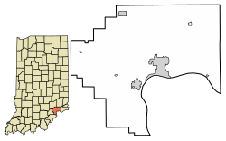 Location of Deputy in Jefferson County, Indiana | |
 Deputy Location of Deputy in Jefferson County, Indiana  Deputy Deputy (the US) | |
| Coordinates: 38°47′39″N 85°39′12″W / 38.79417°N 85.65333°WCoordinates: 38°47′39″N 85°39′12″W / 38.79417°N 85.65333°W | |
| Country | United States |
| State | Indiana |
| County | Jefferson |
| Township | Graham |
| Area | |
| • Total | 0.07 sq mi (0.19 km2) |
| • Land | 0.07 sq mi (0.19 km2) |
| • Water | 0.0 sq mi (0.0 km2) |
| Elevation | 627 ft (191 m) |
| Population (2010)[1] | |
| • Total | 86 |
| • Density | 1,166/sq mi (450.3/km2) |
| ZIP code | 47230 |
| FIPS code | 18-17812[2] |
| GNIS feature ID | 433488[3] |
Deputy is an unincorporated community and census-designated place (CDP) in Graham Township, Jefferson County, Indiana, United States. By road it is approximately 18 miles (29 km) northwest of Madison, the county seat. As of the 2010 census it had a population of 86.[1]
Geography
Deputy is located in western Jefferson County at 38°47′39″N 85°39′12″W / 38.79417°N 85.65333°W, northwest of the center of Graham Township. Indiana State Road 3 forms the eastern edge of the community; the highway leads north 16 miles (26 km) to North Vernon and south 40 miles (64 km) to Jeffersonville.
According to the U.S. Census Bureau, the Deputy CDP has an area of 0.073 square miles (0.19 km2), all of it recorded as land. Lewis Creek flows northward just east of the community, leading in 1 mile (1.6 km) to the Muscatatuck River, part of the White River watershed.
Deputy is located on land that is considered to be of karst topography. The town and the area around it contain numerous sink holes and caves.
Climate
The climate in this area is characterized by hot, humid summers and generally mild to cool winters. According to the Köppen Climate Classification system, Deputy has a humid subtropical climate, abbreviated "Cfa" on climate maps.[4]
Demographics
| Historical population | |||
|---|---|---|---|
| Census | Pop. | %± | |
| U.S. Decennial Census[5] | |||
Description
Primarily an agricultural community, Deputy residents farm timber, corn, soybeans, wheat, hay, tobacco as well as vegetables and fruits in season. Cattle, hogs, chickens, goats, sheep, horses and donkeys are typical of farm animals many residents raise in the Deputy area.
There is no other town or community in the United States named Deputy.
History
Deputy was laid out as a town in March 1871 by Foster C. Wilson, the husband of Margaret Mary Deputy and son-in-law of John and Harriet Deputy.[6]
Local lore - and probably the source of the town's name - indicates that the area was first settled in the 1810s by a number of Deputy families that had migrated to Clark County, Indiana, from Sussex County, Delaware, probably as a result of the conclusion of the Treaty of Fort Wayne in September 1809 which opened up lands in the Indiana territory to American settlement.[7]
Religious centers
Some notable churches in the area are the Deputy United Methodist Church, the Pisgah Methodist Church, the Open Door Baptist Church, the Bethany Baptist Church and the Lick Branch Baptist Church. Deputy is the area where the historic Deputy Camp Meetings were held by the Methodist Episcopal Church as part of the Second Great Awakening movement in the mid-1800s. These camp meetings - which initially featured "round the clock" evangelism and passionate "fire and brimstone" preaching to win new converts - were central features of the outreach of the Methodist church in the American frontiers. The Deputy Camp Meetings were the first such meetings held in Indiana in the late 1840s. They became part of the network of camp meetings organized under the Indiana Conference of the Methodist Episcopal Church. The camp meetings continued in the Deputy area into the 1870s, gradually evolving into permanent congregations who built their own church buildings.[8] Pisgah Methodist Church is the location of the Pisgah cemetery, which holds many graves from the Revolutionary era and Civil War era to the present.
Important places
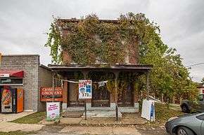
One of the most important places in Deputy (at least to Deputy natives) is Gaffney's Grocery, previously (and still often known as) Nays. Prior to 2008, Gaffney's was owned and operated by David and Judy Gaffney. It is now owned and operated by Bill and Phyllis Miller, a local farm family.[9]
Deputy Pike is the historic road which connects Deputy to the county seat, Madison. It begins as Main Street and then heads east for 13 miles (21 km), becoming Deputy Pike at State Highway 3 and West Deputy Pike Road at North Home Road. It eventually merges with State Highway 7, which runs southeast to Madison. Deputy Pike is a scenic route along the Muskatatuck River ("Big Creek" as it is known locally) along the road's western and central portions and along Harbert's Creek to the east. It runs by several cemeteries such as Robertson Cemetery and through the smaller communities of Wakefield and Volga. It was originally a toll road but has long since been publicly maintained by the county.
A notable historic site that once overlooked Deputy was a large tree. This tree was hundreds of years old and tales of the tree were said to be heard in Native American tribes throughout the area. The tree was located where the United States Post Office is now located.
Some other important places in the Deputy area are the United States Post Office, the Deputy Elementary School and Crop Production Services. The heavily forested rural area surrounding Deputy supports several sawmills including TinyTIMBERS, Baxter Lumber and Phillips Millwork.
Schools
Located in Deputy is the Deputy Elementary School, part of the Madison Consolidated school system. As of 2008, the principal was Kevin Saner, who was recently awarded the Educator of the Year Award. Deputy Elementary School is located near the site of the old Deputy High School. The Deputy Elementary School and the old Deputy High School mascot is a panther.
References
- 1 2 "Geographic Identifiers: 2010 Census Summary File 1 (G001): Deputy CDP, Indiana". American Factfinder. U.S. Census Bureau. Retrieved May 17, 2018.
- ↑ "American FactFinder". United States Census Bureau. Archived from the original on 2013-09-11. Retrieved 2008-01-31.
- ↑ "Deputy, Indiana". Geographic Names Information System. United States Geological Survey. Retrieved 2009-10-10.
- ↑ Climate Summary for Deputy, Indiana
- ↑ "Census of Population and Housing". Census.gov. Retrieved June 4, 2016.
- ↑ Gresham, John M. Biographical and historical souvenir for the counties of Clark, Crawford, Harrison, Floyd, Jefferson, Jennings, Scott and Washington, Indiana (1889), p. 197
- ↑ "US Census Reconstructed Records, 1810, Indiana, Deputy".
- ↑ Corn, Kevin J. (2007). Forward Be Our Watchword: Indiana Methodism and the Modern Middle Class. University Press. p. 92. Retrieved 2014-03-04.
- ↑ Peggy Vlerebome (04/10/2010). "Gaffney's Grocery: Deputy store to change hands but little else as Millers take over". Madison Courier. Check date values in:
|date=(help)
Municipalities and communities of Jefferson County, Indiana, United States | ||
|---|---|---|
| City | ||
| Towns | ||
| Townships | ||
| CDPs | ||
| Other unincorporated communities | ||
| Footnotes | ‡This populated place also has portions in an adjacent county or counties | |