Denklingen
| Denklingen | ||
|---|---|---|
| ||
 Denklingen Location of Denklingen within Landsberg am Lech district 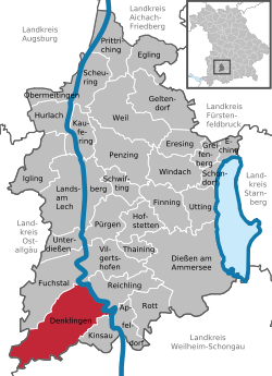 | ||
| Coordinates: 47°55′N 10°51′E / 47.917°N 10.850°ECoordinates: 47°55′N 10°51′E / 47.917°N 10.850°E | ||
| Country | Germany | |
| State | Bavaria | |
| Admin. region | Oberbayern | |
| District | Landsberg am Lech | |
| Government | ||
| • Mayor | Michael Kießling | |
| Area | ||
| • Total | 56.76 km2 (21.92 sq mi) | |
| Elevation | 708 m (2,323 ft) | |
| Population (2017-12-31)[1] | ||
| • Total | 2,671 | |
| • Density | 47/km2 (120/sq mi) | |
| Time zone | CET/CEST (UTC+1/+2) | |
| Postal codes | 86920 | |
| Dialling codes | 08243 (Denklingen) 08869 (Epfach) | |
| Vehicle registration | LL | |
| Website | www.denklingen.de | |

Denklingen is a municipality in the district of Landsberg (also called Landsberg am Lech) in Bavaria in Germany. The former municipality of Epfach, which has a history back to the Roman period, is now part of Denklingen.
Location of Denklingen (colored red) within the Landsberg district.
Geography
Denklingen is the most southwesterly municipality in the district of Landsberg. It is located on flats to the west of the Lech river. It is at the edge of Denklinger Rotwalds (red forest of Denklingen) and Sachsenrieder forest.
References
- ↑ "Fortschreibung des Bevölkerungsstandes". Bayerisches Landesamt für Statistik und Datenverarbeitung (in German). September 2018.
| Authority control |
|---|
This article is issued from
Wikipedia.
The text is licensed under Creative Commons - Attribution - Sharealike.
Additional terms may apply for the media files.