Deepdene (garden)
Deepdene was an estate and country house occupying the south-east of Dorking, Surrey, England, the aspects of it that remain being a large minority of its woodland garden, interwoven amidst Dorking Golf Course. The remains of the gardens are Grade II* listed with the adjoining Chart Park on the Register of Historic Parks and Gardens.[1]
History of the estate
A hillside manor that descended from earlier Earls of Surrey throughout the Middle Ages to the 23rd Earl of Arundel and Surrey who became the 5th Duke of Norfolk in 1652, it was sold by his descendant the 11th Duke of Norfolk in 1807 to the Hope banking family. Its descent was not straightforward, the family successfully put forward an acceptable stance and level of regal support in the Wars of the Roses, English Reformation and Marian Persecutions, the English Civil War and avoided the ravages of Popish Plot Anti-Catholicism which plagued five years of the reign of Charles II of England such as resulted in the execution of close kinsman William Howard, 1st Viscount Stafford. The Duke of Norfolk of this family is today one of two people to be guaranteed a seat in the House of Lords, whose family arms appears in the chamber and who has mostly ceremonial roles he is expected to perform, rather than to speak in debates.[2]
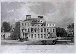
At the height of the regency architecture period the house was remodelled by the architect, William Atkinson for banker and celebrated interior designer Thomas Hope, work that completed in 1823; he also developed the grounds in a particular picturesque style.[3] The house was occupied by his son, the MP Henry Hope from c. 1840.[4]
In 1836-41 the house was again remodelled, by the architect Alexander Roos, in the form of a great Roman villa.[5]
Latter occupants and demolition
It was let, for a while to Lord William Beresford VC and his wife Lilian, formerly Duchess of Marlborough. Deepdene was placed into receivership and sold in 1917. It became a hotel during the inter-war years. During the Second World War it became the home of various offices of the Southern Railway mainly the Chief Accounts office which was 'temporarily' evacuated there from London. This 'temporary' evacuation lasted until around 1965 when the office was relocated to East Croydon. Deepdene House was demolished by British Rail in 1967, and in 1969, replaced by a large, ugly concrete-and-glass office block by architects Scherrer & Hicks, which is of "indescribable mediocrity".[6] The site has since been redeveloped as a green office estate, and partly sold for private development. Pevsner sums up the demise of Hope's masterpiece as 'a disgraceful and depressing story'.[7]
Remnant gardens and Dorking Golf Course
The gardens were laid out by Howard, the 5th Duke, with gradual changes, in Italianate picturesque style.[8] The horticulturalist and planner John Claudius Loudon praised the gardens as an exemplar of landscape architecture, one of the earliest uses of that phrase. A large minority of the gardens remain, which have been retained as features visible from the clubhouse to compliment the holes and rough of Dorking Golf Course. Parts of the garden have been sold for residential homes and gardens.[1] A project has recently restored and re-linked remaining parts of the garden and opened the Deepdene Trail to the public.[9]
References
- 1 2 Historic England, "The Deepdene (including Chart Park) (1000143)", National Heritage List for England, retrieved 21 August 2017
- ↑ "Register of Hereditary Peers Report". UK Parliament. Retrieved 8 March 2017.
- ↑ Riddy, Paula (2016). "'The Guidebook and the Picturesque: Thomas Hope and the Deepdene'". Georgian Group Journal. XXIV: 159–180.
- ↑ Hope Springs Eternal
- ↑ "Alexander Roos". Dictionary of Scottish Architects. Retrieved 14 June 2015.
- ↑ Robinson, John Martin. Felling the Ancient Oaks.
- ↑ Nairn, Ian; Pevsner, Nikolaus; Cherry, Bridget (1971). "Surrey". Penguin. ISBN 978-0140710212.
- ↑ England's lost Downtons Daily Mail, 16 February 2012
- ↑ "Hope Springs Eternal Project".
External links

- The Deepdene Trail