Dawes Point, New South Wales
| Dawes Point Sydney, New South Wales | |||||||||||||||
|---|---|---|---|---|---|---|---|---|---|---|---|---|---|---|---|
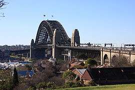 Sydney Harbour Bridge, viewed from Observatory Hill | |||||||||||||||
| Population | 357 (2016 census)[1] | ||||||||||||||
| • Density | 3,600/km2 (9,000/sq mi) | ||||||||||||||
| Postcode(s) | 2000 | ||||||||||||||
| Area | 0.1 km2 (0.0 sq mi) | ||||||||||||||
| Location | 1 km (1 mi) north of Sydney CBD | ||||||||||||||
| LGA(s) | City of Sydney | ||||||||||||||
| Parish | St. Philip | ||||||||||||||
| State electorate(s) | Sydney | ||||||||||||||
| Federal Division(s) | Sydney | ||||||||||||||
| |||||||||||||||
Dawes Point is a suburb of the City of Sydney, in the state of New South Wales, Australia. Dawes Point is located on the north-western edge of the Sydney central business district, at the southern end of Sydney Harbour Bridge, adjacent to The Rocks. Sections of Dawes Point have been included as part of The Rocks area in the past and some residents and businesses still use it in their address.
History
The area was originally known by the Aboriginal names of Tar-ra and Tullagalla. This was later changed to Point Maskelyne in honour of Reverend Dr Nevil Maskelyne, British Astronomer Royal. He sent out the first astronomical instruments which were established at the point in the country's first observatory, by Lieutenant William Dawes (1762-1836), astronomer with the First Fleet. The point was renamed in honour of Dawes.[2]
It was also the site of the first guns mounted in Sydney by Dawes in 1788, contained Sydney's first cemetery and later Dawes Point Battery. Walsh Bay was the site of Sydney's port facilities. The wharves were converted to apartments, theatres, restaurants, cafes and a hotel.
By the 1840s, the people of Dawes Point and Millers Point were a maritime community in which rich and poor mixed more than elsewhere in Sydney. Wharf owners and traders lived and worked beside those who worked on the wharves and bond stores, as well as those who arrived and left on ships.[3] Only two of the merchant houses, built by and for the early wharf owners, survive. One is Walker's 50-foot wide villa built around 1825 and now part of Milton Terrace at 7-9 Lower Fort Street; the other is the home and offices of Edwards and Hunter, built in 1833 above their wharves which is where the Wharf Theatre now stands.[4]
The fortunes of Dawes Point and Millers Point fluctuated more than elsewhere in Sydney. Mostly prosperous in its early years, the area was less desirable by the 1890s, and in 1900 there was a catastrophic event that led to a complete reshaping of Millers Point.
At the beginning of the 20th century, the government compulsorily acquired all private wharves, homes and commercial properties in the Rocks, Dawes Point and Millers Point. Modern and efficient wharves with dual level access were built, as well as new accommodation for workers, such as the Workers Flats of Lower Fort Street designed by Government Architect Vernon.[5]
Most people still believe this redevelopment can be attributed entirely to an outbreak of plague in 1900, with the government acting benevolently as it demolished homes as well as wharves, and not for the last time decimated a community, while presenting their actions as ‘slum clearance’. In the 1960s and '70s, the government tried again to clear the area and build high-rise offices, but this was thwarted by the Green Bans, supported community and unions.
Population
In the 2016 Census, there were 357 people in Dawes Point. 63.8% of people were born in Australia and 76.2% of people only spoke English at home. The most common response for religion was No Religion at 39.9%.
Median mortgage repayments were $5,200 a month or $62,400 a year, the highest median mortgage repayment in the greater Sydney area.[1][6]
Culture
The Sydney Theatre and The Wharf Theatre, which are part of the Sydney Theatre Company, are located in Dawes Point.
Gallery
 The Sydney Theatre and The Wharf Theatre, which are part of the Sydney Theatre Company, are located in Dawes Point
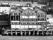
 Pier One on Walsh Bay
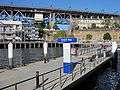 Walsh Bay ferry wharf
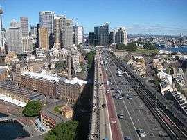 Southern approach of the Sydney Harbour Bridge with Dawes Point to the right.
_01.jpg) Terraces, Pottinger Street (c. 2007)
Terraces, Pottinger Street (c. 2007)_03.jpg) Terraces, Pottinger Street (c. 2007)
Terraces, Pottinger Street (c. 2007) The Sydney Opera House seen from Dawes Point
.jpg) Aerial view of Dawes point in the 1930s
Aerial view of Dawes point in the 1930s
References
- 1 2 Australian Bureau of Statistics (27 June 2017). "Dawes Point (State Suburb)". 2016 Census QuickStats. Retrieved 2 July 2017.

- ↑ The Book of Sydney Suburbs, Compiled by Frances Pollon, Angus & Robertson Publishers, 1990, Published in Australia ISBN 0-207-14495-8, page 81
- ↑ "1840". MILLERS POINT.
- ↑ "37 & 35 Lower Fort Street". MILLERS POINT.
- ↑ "The Workers Flats of Millers Point". MILLERS POINT.
- ↑ http://www.smh.com.au/business/property/sydneys-biggest-mortgage-bills-how-your-suburb-compares-20170817-gxy1xi.html
External links
![]()
- Shirley Fitzgerald (2008). "Dawes Point". Dictionary of Sydney. Retrieved 26 September 2015. [CC-By-SA]
Coordinates: 33°51′22″S 151°12′25″E / 33.856°S 151.207°E
| Events | 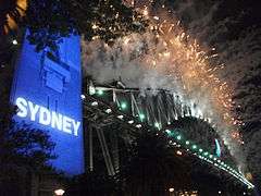 | ||||
|---|---|---|---|---|---|
| Venues |
| ||||
| Related |
| ||||