Darul Aman Palace
| Darul Aman Palace | |
|---|---|
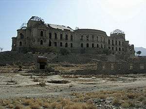 Darul Aman Palace in 2008 | |
| General information | |
| Status | Under reconstruction |
| Type | Palace |
| Architectural style | Neoclassical |
| Town or city | Kabul |
| Country |
|
Darul Aman Palace (Persian: قصر دارالامان; Pashto: د دارالامان ماڼۍ; "abode of peace" or, in a double meaning "abode of Aman[ullah]")[1] is a ruined palace located about sixteen kilometers (ten miles) south-west outside of the center of Kabul, Afghanistan. As of 2017, progress is being made on a major project intended to fully renovate the building by 2019.[2]
History
Construction of the Darul Aman Palace began in the early 1920s as a part of the endeavours of King Amanullah Khan to modernize Afghanistan. It was to be part of the new capital city called Darulaman, connected to Kabul by a narrow gauge railway.[3] The palace is considered to be a testimony of Afghanistan-Germany friendship, as it was designed by German engineer Walter Harten and his team of engineers.[4]
The palace is an imposing neoclassical building on a hilltop overlooking a flat, dusty valley in the western part of the Afghan capital. Designed by French and German architects, it was one of the first buildings in the country to get central heating and running water.[2] Intended as the seat of a future parliament, the building remained unused and partially complete for many years after religious conservatives under Habibullah Kalakani forced Amanullah from power in 1929, and halted his reforms. In later years it served as the medical school for Kabul University, as well a warehouse, and the seat of several smaller ministries.[2]
The building was gutted by fire on December 14, 1968, and afterwards restored to house the Ministry of Defense during the 1970s and 1980s. In the Communist coup of 1978, the building was once more set on fire. Much of the building was damaged by tank fire during Shahnawaz Tanai's failed coup attempt on March 6, 1990.[5] It was once again damaged in the 1990s as rival Mujahideen factions fought for control of Kabul. Heavy shelling by the Mujahideen left the palace a gutted ruin, and it was mostly used as a refugee settlement and a nomad camp until the early 2000s, when it became a battalion headquarters for the Afghan National Army.[2]
In 2005, a plan was unveiled to refurbish the palace for use as the seat of Afghanistan's future parliament.[6] It was to be funded primarily by private donations from foreigners and wealthy Afghans. The palace one of several targets in a series of attacks launched on April 15, 2012, for which the Taliban claimed responsibility.[7] Eventually it was decided to develop a new building opposite the palace to house the parliament, with Indian help. Construction was completed in 2015.
In early 2016 work began on a US$ 20 million restoration project, intended to renovate the palace in time for the centenary of Afghanistan’s full independence in 1919. Nearly 600 tons of debris was initially removed from the 150-room building, and by the spring of 2017, workers were taking down plaster and concrete from the inner walls.[2] Over 80 engineers and architects are involved in the project, of which 25 percent are female. It was announced in February 2018 that almost 50 percent of the renovation was complete.[8]
Gallery
 Palace in 1986
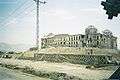 Darul Aman Palace northern elevation showing shelling damage inflicted during mujahideen fighting for Kabul after Soviet withdrawal
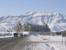 Heavy snowfall at the Darul Aman Palace in Kabul
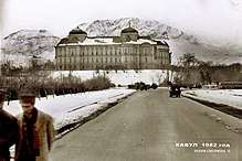 The palace in 1982, with Soviet Red Army trucks visible
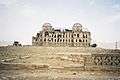 Darul Aman Palace western elevation
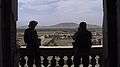 2 US Special Forces soldiers view Kabul looking north.
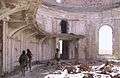 US Commandos patrolling a heavily bombed out room in the palace in 2002.
 The inside of the palace is in very bad shape, as of July 2010.
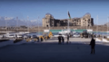 View from the Afghan Parliament building's front, revealing the ruins of the Darul Aman palace, under reconstruction as of December 2015.
See also
- National Assembly of Afghanistan, the parliament of Afghanistan located opposite the Darul Aman Palace, and completed in December 2015.
- Tajbeg Palace, located on a nearby hill and built as a residence for Amanullah, his wife, Queen Soraya, and their family.
- Bagh-e Bala Palace, a palace built as a leisure home for Abdur Rahman Khan in 1893
References
- ↑ Clements, Frank (2003) Conflict in Afghanistan, a Historical Encyclopaedia. ABC-CLIO, Santa Barbara, ISBN 1-85109-402-4, page 29, 67.
- 1 2 3 4 5 "Saving an Afghan Symbol, With Afghans Only". The New York Times. 2017-04-05. Retrieved 2017-04-06.
- ↑ "Kabul to Darulaman railway". Sndrewgrantham.co.uk. Retrieved 2016-02-24.
- ↑ Azadi, Sada-e. "Cabinet Approves Darul Aman Palace Reconstruction Budget". www.sada-e-azadi.net.
- ↑ Ghani, Mariam & Ashraf (8 September 2012). "Palace of Abandoned Dreams".
- ↑ "Place to see: Darul Aman Palace, Kabul, Afghanistan". Archived from the original on December 21, 2009. Retrieved February 1, 2010.
- ↑ "Taliban strike across Afghanistan in 'spring offensive'". BBC News. 16 April 2012.
- ↑ "Renovation of Darul Aman Palace To Resume In Spring - TOLOnews".
External links
| Wikimedia Commons has media related to Darul-Aman Palace. |
- Darul-Aman Project for Kabul
- The story of the german ingenieur Wilhelm Rieck. Lots of historical pictures
- The Shattered Remains of Afghanistan’s Versailles
- In restoring a century-old palace, a step toward rebuilding Afghanistan’s independence on YouTube, Sep 12, 2016 PBS NewsHour
Coordinates: 34°27′54.78″N 69°7′9.47″E / 34.4652167°N 69.1192972°E
