Dargo, Victoria
| Dargo Victoria | |
|---|---|
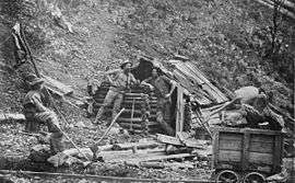 Prospector's hut Upper Dargo, 1870 | |
 Dargo | |
| Coordinates | 37°29′S 147°16′E / 37.483°S 147.267°ECoordinates: 37°29′S 147°16′E / 37.483°S 147.267°E |
| Population | 144 (2006 census)[1] |
| Postcode(s) | 3862 |
| Elevation | 203 m (666 ft) |
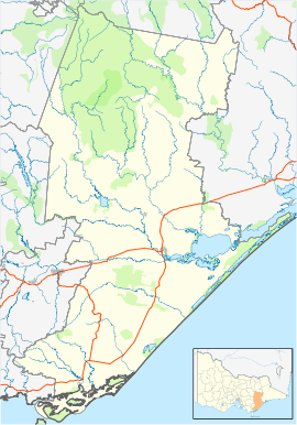
| Location |
|
| LGA(s) | Shire of Wellington |
| State electorate(s) | Gippsland East |
| Federal Division(s) | Gippsland |
Dargo is a town in Victoria, Australia, located 348 kilometres (216 mi) east of Melbourne, in the Shire of Wellington. At the 2006 census, Dargo and the surrounding area had a population of 144.[1]
The town provided a stopover for Victorian Gold Rush miners on their way to the goldfields of Grant, Talbotville, and Crooked River. The Post Office opened on 18 March 1868.[2]
Today the town is a producer of timber, and stockmen seasonally reside on the nearby Dargo High Plains. The town is a popular destination for four-wheel drive enthusiasts, bushwalkers, sambar deer hunters, and trout fisherman. An annual Walnut Festival formerly ran through the Australian Easter holiday period and was usually well attended.
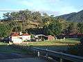 The Dargo Hotel, a major social gathering point for the district.
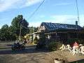 The Dargo Store, an important refuel and resupply point.
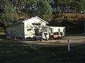 The Dargo Community Hall.
References
| Wikimedia Commons has media related to Dargo, Victoria. |
- 1 2 Australian Bureau of Statistics (25 October 2007). "Dargo (State Suburb)". 2006 Census QuickStats. Retrieved 2007-07-26.
- ↑ Premier Postal History, Post Office List, retrieved 2008-04-11
External links
This article is issued from
Wikipedia.
The text is licensed under Creative Commons - Attribution - Sharealike.
Additional terms may apply for the media files.