Dardanelles Cone
| Dardanelles Cone | |
|---|---|
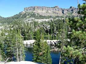 Sword Lake and the Dardanelles Cone | |
| Highest point | |
| Elevation | 9,527 ft (2,904 m) NAVD 88[1] |
| Prominence | 1,382 ft (421 m) [2] |
| Coordinates | 38°24′17″N 119°52′19″W / 38.404676236°N 119.872020533°WCoordinates: 38°24′17″N 119°52′19″W / 38.404676236°N 119.872020533°W [1] |
| Geography | |
 Dardanelles Cone | |
| Parent range | Sierra Nevada |
| Topo map | USGS Dardanelles Cone |
Dardanelles Cone is a mountain peak in the Carson-Iceberg Wilderness on the Stanislaus National Forest. It lies near Sonora Pass in the Sierra Nevada of California. It is between State Route 4 and State Route 108.
References
- 1 2 "Dardanelles". NGS data sheet. U.S. National Geodetic Survey.
- ↑ "Dardanelles Cone, California". Peakbagger.com. Retrieved 2012-12-12.
External links
- "Dardanelles Cone". Geographic Names Information System. United States Geological Survey.
- "Carson-Iceberg Wilderness". Humboldt-Toiyabe National Forest, USFS.
This article is issued from
Wikipedia.
The text is licensed under Creative Commons - Attribution - Sharealike.
Additional terms may apply for the media files.