D'Entrecasteaux Channel
| D'Entrecasteaux Channel | |
|---|---|
 D'Entrecasteaux Channel Location in Tasmania | |
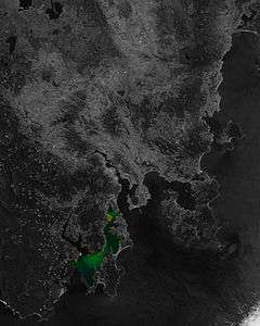 South East Tasmania with D'Entrecasteaux Channel highlighted. | |
| Location | South East Tasmania |
| Coordinates | 43°13′S 147°17′E / 43.217°S 147.283°ECoordinates: 43°13′S 147°17′E / 43.217°S 147.283°E |
| Type | Channel |
| Etymology | Vice-Admiral Bruni D'Entrecasteaux[1] |
| River sources | Derwent River; Huon River |
| Primary outflows | Tasman Sea |
| Ocean/sea sources | South Pacific Ocean |
| Basin countries | Australia |
| Settlements | Snug, Margate, Kettering, Woodbridge, Flowerpot, Middleton, Gordon |
| References | [2] |
The D'Entrecasteaux Channel /ˌdɒntrəˈkæstoʊ/ is a body of water located between Bruny Island and the south-east of the mainland of Tasmania, Australia. The channel is the mouth for the estuaries of the Derwent and the Huon Rivers and empties into the Tasman Sea of the South Pacific Ocean. It was sighted by Abel Tasman in 1642 and surveyed in 1792 by Bruni d'Entrecasteaux.[3]
Towns on the D'Entrecasteaux Channel include Snug, Margate, Kettering, Woodbridge, Flowerpot, Middleton and Gordon.[4]
History
According to The Mercury newspaper, the channel "..... was discovered on April 20. 1792, by the celebrated French "Vice-Admiral Bruni D'Entrecasteaux, who, in the ships Recherche and Esperance, was searching for ill-fated La Perouse. Visiting Van Diemen's Land for the first time, he was attempting to find an anchorage in Adventure Bay, when, being himself ill in bed, the ships' navigators entered the channel to the west of Bruny Island, instead of going to the eastward of it. Thus, the discovery of the great channel was due to an accident. This is Labillardiere's account of the matter. A wrong bearing taken of the Mewstone accounts for the French navigator's error."[1]
Whalng stations operated on the shores of the channel in the first half of the 19th century.[5]
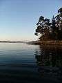
Geography and environment
The D'Entrecastaux Channel region sheltered by Bruny Island is increasingly affected by foreshore erosion, in some areas sandbagging aims to reduce the effects.[6]
The channel is a breeding ground for scallops.[7] Prior to 1969, fishing dredges were used to collect scallops from the seafloor.[7] Damage caused by the dredging has led to collection by scuba divers.[7]
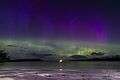
The D'Entrecasteaux Channel has become a popular location for keen photographers to capture images of the Aurora Australis with its numerous southern-facing water views and beaches, although light pollution from the numerous salmon farms is now starting to impact on this visual beauty from many locations.
Gallery
See also
References
- 1 2 Nomen, ed. (16 September 1911). "TASMANIAN NOMENCLATURE. THE PLACE-NAMES OF THE STATE. A RECORD OF ORIGINS AND DATES. No. X". The Mercury. p. 10 – via National Library of Australia.
- ↑ "Map of D'Entrecasteaux Channel, TAS". Bonzle Digital Atlas of Australia. 2015. Retrieved 25 June 2016.
- ↑ "D'Entrecasteaux Channel." Encyclopædia Britannica. 2006. Encyclopædia Britannica Online. Retrieved on 15 June 2014
- ↑ D'Entrecasteaux Channel The Huon Trail. Retrieved on 15 June 2014
- ↑ Michael Nash, The Bay whalers; Tasmania's shore-based whaling industry, Naverine, Camberra, 2003, pp.139-41,
- ↑ Flora Fox, Flora Fox, News and Information about Southern Tasmania Archived 17 July 2011 at the Wayback Machine. 2011
- 1 2 3 Walker, Margaret (1991). "What price Tasmanian scallops? A report of morbidity and mortality associated with the scallop diving season in Tasmania 1990". South Pacific Underwater Medicine Society Journal. 21 (1). Retrieved 2013-07-16.
External links
- "Snapshot of the state of the D'Entrecasteaux Channel and Lower Huon Estuary" (PDF). D'Entrecasteaux Channel Project. Natural Resource Management South; Tasmanian Government. 2012.
- Parsons, Karen; Ecomarine Consulting (October 2012). "State of the D'Entrecasteaux Channel and the lower Huon Estuary" (PDF). Report for the D'Entrecasteaux Channel Project. Tasmania: Kingborough Council.
- PROTECTED ENVIRONMENTAL VALUES - KINGBOROUGH AND CHANNEL (PDF) (Map). 1:200,000. Department of Primary Industries, Water and Environment; Tasmanian Government. October 2000.
- "CATCHMENTS IN THE KINGBOROUGH MUNICIPAL AREA (excluding the Derwent Estuary catchment) AND D'ENTRECASTEAUX CHANNEL" (PDF). ENVIRONMENTAL MANAGEMENT GOALS for TASMANIAN WATERS. Department of Primary Industries, Water and Environment; Tasmanian Government. March 2003.
Southern region of Tasmania, Australia | |||||
|---|---|---|---|---|---|
| City Other settlements | |||||
| Governance | |||||
| Mountains | |||||
| Protected areas, parks and reserves | |||||
| Rivers | |||||
| Harbours, bays, inlets and estuaries | |||||
| Coastal features | |||||
| Transport | |||||
| Landmarks |
| ||||
| Islands | |||||
| Books and newspapers | |||||
| Flora, fauna, and fishlife | |||||
| Bioregions | |||||
| Indigenous heritage | |||||
| Other | |||||
| |||||