Cut, Texas
| Cut, Texas | |
|---|---|
| Unincorporated community | |
 Cut  Cut | |
| Coordinates: 31°13′19″N 95°28′55″W / 31.22194°N 95.48194°WCoordinates: 31°13′19″N 95°28′55″W / 31.22194°N 95.48194°W | |
| Country | United States |
| State | Texas |
| County | Houston |
| Elevation | 371 ft (113 m) |
| Time zone | UTC-6 (Central (CST)) |
| • Summer (DST) | UTC-5 (CDT) |
| ZIP code | 75835 |
Cut (also known as Paso or Paso Switch) is an unincorporated community in Houston County, Texas.[1] Cut is located on Texas State Highway 19 6 miles (9.7 km) south of Crockett. The town was founded around a watering rest stop along the Houston and Great Northern Railroad, and was originally called Paso or Paso Switch, and was renamed in 1900. By the 1990s, Cut had been abandoned.[2]
References
- ↑ "Cut". Geographic Names Information System. United States Geological Survey.
- ↑ Long, Christopher. "Cut, TX". Handbook of Texas Online. Texas State Historical Association. Retrieved October 13, 2012.
Municipalities and communities of Houston County, Texas, United States | ||
|---|---|---|
| Cities | 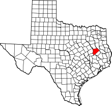 | |
| Unincorporated communities | ||
| Ghost towns | ||
| Footnotes | ‡This populated place also has portions in an adjacent county or counties | |
This article is issued from
Wikipedia.
The text is licensed under Creative Commons - Attribution - Sharealike.
Additional terms may apply for the media files.