Crystal Lake Airport
| Crystal Lake Airport | |||||||||||
|---|---|---|---|---|---|---|---|---|---|---|---|
 | |||||||||||
| Summary | |||||||||||
| Airport type | Public use | ||||||||||
| Owner | Peterson Farms | ||||||||||
| Serves | Decatur, Arkansas | ||||||||||
| Elevation AMSL | 1,177 ft / 359 m | ||||||||||
| Coordinates | 36°20′37″N 094°26′41″W / 36.34361°N 94.44472°WCoordinates: 36°20′37″N 094°26′41″W / 36.34361°N 94.44472°W | ||||||||||
| Map | |||||||||||
 5M5 Location of airport in Arkansas | |||||||||||
| Runways | |||||||||||
| |||||||||||
| Statistics (2010) | |||||||||||
| |||||||||||
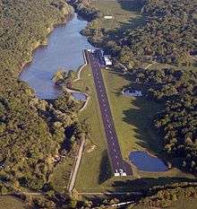
Crystal Lake Airport (FAA LID: 5M5) is a privately owned, public use airport located two nautical miles (4 km) northeast of the central business district of Decatur, a city in Benton County, Arkansas, United States.[1]
Facilities and aircraft
Crystal Lake Airport covers an area of 10 acres (4 ha) at an elevation of 1,177 feet (359 m) above mean sea level. It has one runway designated 13/31 with an asphalt surface measuring 3,863 by 75 feet (1,177 x 23 m).[1]
For the 12-month period ending March 31, 2010, the airport had 750 general aviation aircraft operations, an average of 62 per month. At that time there were 3 aircraft based at this airport, all single-engine.[1]
References
External links
- "Decatur / Crystal Lake (5M5)" (PDF). Archived from the original (PDF) on 2010-11-03. at the Arkansas Department of Aeronautics
- Aerial image as of April 2000 from USGS The National Map
- Airfield photos from U.S. Civil Air Patrol at the Wayback Machine (archived September 23, 2006)
- FAA Terminal Procedures for 5M5, effective October 11, 2018
- Resources for this airport:
- FAA airport information for 5M5
- AirNav airport information for 5M5
- FlightAware airport information and live flight tracker
- SkyVector aeronautical chart for 5M5
This article is issued from
Wikipedia.
The text is licensed under Creative Commons - Attribution - Sharealike.
Additional terms may apply for the media files.