Crown of Scotland (hill)
| Crown of Scotland | |
|---|---|
 Crown of Scotland[1] | |
| Highest point | |
| Elevation | 538 m (1,765 ft) |
| Coordinates | 55°22′53″N 3°27′54″W / 55.38145°N 3.46492°WCoordinates: 55°22′53″N 3°27′54″W / 55.38145°N 3.46492°W |
| Geography | |
| OS grid | NT081150 |
| Geology | |
| Mountain type | sub Donald Dewey |
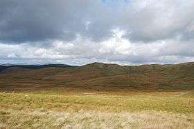
The Crown of Scotland is a hill in Dumfries and Galloway, Scotland.
At a relatively small elevation from the surrounding peaks, it is situated to the north of the Devil's Beef Tub and the town of Moffat.
The hill's unusual name derives from the alliance made between Robert the Bruce and James Douglas, Lord of Douglas upon its summit in 1306, following the former's murder of the Red Comyn at Greyfriars kirk in Dumfries, and when Bruce was making for Glasgow to meet with Bishop Wishart.
Development
In 2008 a planning application was made to erect 36 wind turbines concentrated on the summit and its surrounding peaks. This application was rejected following much local objection. Currently (December 2011) a revised plan for 24 turbines is in process.[2]
References
- ↑ Interactive map of proposed development at Earlshaugh, 1b being the potential view pictured, with The Crown of Scotland at its centre
- ↑ Keddie, Andrew (24 September 2011). "Wind farm firm back with scaled down Devil's Beef Tub project". Southern Reporter. Retrieved 28 January 2017.
External links
| Wikimedia Commons has media related to Crown of Scotland (hill). |
This article is issued from
Wikipedia.
The text is licensed under Creative Commons - Attribution - Sharealike.
Additional terms may apply for the media files.