Crowdecote
| Crowdecote | |
|---|---|
 | |
 Crowdecote Crowdecote shown within Derbyshire | |
| OS grid reference | SK100651 |
| District | |
| Shire county | |
| Region | |
| Country | England |
| Sovereign state | United Kingdom |
| Post town | BUXTON |
| Postcode district | SK17 |
| Police | Derbyshire |
| Fire | Derbyshire |
| Ambulance | East Midlands |
| EU Parliament | East Midlands |
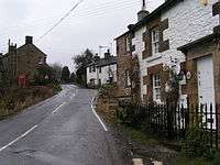
Crowdecote (sometimes spelled Crowdicote) is a small village in Derbyshire, England.[1][2] It is situated on the border between Derbyshire and Staffordshire about 6 miles (9.7 km) south of Buxton. Crowdecote is part of Hartington Middle Quarter civil parish. It is thought that the name Crowdecote derives from Cruda’s Cot (Cruda was a Saxon landowner while 'cot' meant a form of shelter). Crowdecote is popular with walkers and ramblers because of its proximity to Chrome Hill, High Wheeldon and Parkhouse Hill to the north and Dovedale to the south.
References
- ↑ Ordnance Survey: Landranger map sheet 119 Buxton & Matlock (Chesterfield, Bakewell & Dove Dale) (Map). Ordnance Survey. 2012. ISBN 9780319231890.
- ↑ "Ordnance Survey: 1:50,000 Scale Gazetteer" (csv (download)). www.ordnancesurvey.co.uk. Ordnance Survey. 1 January 2016. Retrieved 18 February 2016.
External links
![]()
This article is issued from
Wikipedia.
The text is licensed under Creative Commons - Attribution - Sharealike.
Additional terms may apply for the media files.