Crossroads, New Mexico
| Crossroads | |
|---|---|
| Unincorporated community | |
 Crossroads Location within the state of New Mexico  Crossroads Crossroads (the US) | |
| Coordinates: 33°30′44″N 103°20′23″W / 33.51222°N 103.33972°WCoordinates: 33°30′44″N 103°20′23″W / 33.51222°N 103.33972°W | |
| Country | United States |
| State | New Mexico |
| County | Lea |
| Elevation | 4,121 ft (1,256 m) |
| Time zone | UTC-7 (Mountain (MST)) |
| • Summer (DST) | UTC-6 (MDT) |
| ZIP codes | 88114[1] |
| Area code(s) | 575 |
| GNIS feature ID | 888099[2] |
Crossroads is an unincorporated community located in Lea County, New Mexico, United States. The community is located at the junction of New Mexico State Road 206 and New Mexico State Road 508 17.7 miles (28.5 km) north of Tatum. Crossroads had its own post office until April 29, 1995; it still has its own ZIP code, 88114.[1][3]
Notable residents
- Anna Crook, member of the New Mexico House of Representatives, was born in Crossroads
References
- 1 2 United States Postal Service. "USPS - Look Up a ZIP Code". Retrieved November 30, 2014.
- ↑ "Crossroads". Geographic Names Information System. United States Geological Survey.
- ↑ "Postmaster Finder - Post Offices by ZIP Code". United States Postal Service. Retrieved November 30, 2014.
Municipalities and communities of Lea County, New Mexico, United States | ||
|---|---|---|
| Cities | 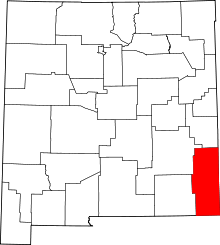 | |
| Town | ||
| CDPs | ||
| Other unincorporated communities | ||
This article is issued from
Wikipedia.
The text is licensed under Creative Commons - Attribution - Sharealike.
Additional terms may apply for the media files.