Crossford railway station
| Crossford | |
|---|---|
| Location | |
| Place | Crossford |
| Area | Dumfries and Galloway |
| Operations | |
| Original company | Cairn Valley Railway |
| Pre-grouping | Glasgow & South Western |
| History | |
| 1 March 1905 | Opened |
| 3 May 1943 | Closed |
| Disused railway stations in the United Kingdom | |
|
Closed railway stations in Britain A B C D–F G H–J K–L M–O P–R S T–V W–Z | |
|
| |
Crossford is a closed station of the Cairn Valley Light Railway branch, from Dumfries. It served the rural area of Crossford in Dumfries and Galloway The line was closed to passengers in 1943.[1]
History
The CVR was nominally independent, but was in reality controlled by the Glasgow and South Western Railway.[2] The line was closed to passengers on 3 May 1943, during WW2[3] and to freight on 4 July 1949,[4] and the track lifted in 1953. 1947 is also quoted as a date of complete closure.[2]
The siding was worked by down trains only, goods for Dumfries being taken to the nearest station along. The points were unlocked with an Annett's key that was kept in a locked box on a post adjacent to the point.[5]
Trains were controlled by a 'lock and block' system whereby the trains operated treadles on the single line to interact with the block instruments.[2]
Views at the old station
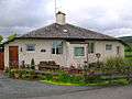 Crossford's old station master's house.
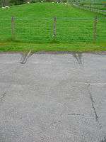 Rails still in the road at the level crossing.
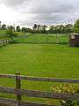 The course of the trackbed running towards Moniaive.
See also
References
Notes
Sources
- Awdry, Christopher (1990). Encyclopaedia of British Railway Companies. Sparkford: Patrick Stephens Ltd. ISBN 1-8526-0049-7. OCLC 19514063. CN 8983.
- Sanders, Keith and Hodgins, Douglas (1995). British Railways. Past and Present South West Scotland. No. 19. ISBN 1-85895-074-0.
- Thomas, David St John & Whitehouse, Patrick (1993). The Romance of Scotlands Railways. Newton Abbot : David St John Thomas. ISBN 0-946537-89-5.
| Preceding station | Historical railways | Following station | ||
|---|---|---|---|---|
| Dunscore | Glasgow and South Western Railway Cairn Valley Railway |
Kirkland | ||