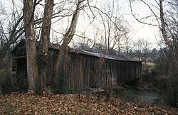
Cromer's Mill Covered Bridge
|
Cromer's Mill Covered Bridge | |
 | |
 | |
| Nearest city | Carnesville, Georgia |
|---|---|
| Coordinates | 34°16′29″N 83°15′57″W / 34.27472°N 83.26583°WCoordinates: 34°16′29″N 83°15′57″W / 34.27472°N 83.26583°W |
| Area | 5 acres (2.0 ha) |
| Built | 1907 |
| Built by | Hunt, James M. |
| Architectural style | Town Lattice |
| NRHP reference # | 76000619[1] |
| Added to NRHP | August 17, 1976 |
The Cromer's Mill Covered Bridge, spanning Nails Creek near Carnesville, Georgia, was built in 1907. It was listed on the National Register of Historic Places in 1976.[1]
It is a Town Lattice truss bridge. It has also been known as Nails Creek Covered Bridge.
It is located 8 miles (13 km) south of Carnesville at Nails Creek.
The bridge rests on stone abutments at its ends and a central pier. A steel truss made of 12-inch steel I-beams was added under the north end of the bridge. And later a single wooden pole was installed to support one side of the bridge.[2]
References
- 1 2 National Park Service (2013-11-02). "National Register Information System". National Register of Historic Places. National Park Service.
- ↑ David T. Agnew; James G. Bogle (January 7, 1975). "National Register of Historic Places Inventory/Nomination: Cromer's Mill Covered Bridge". National Park Service. Retrieved September 8, 2018. With accompanying two photos from 1974 and 1975
| Topics | |
|---|---|
| Lists by states |
|
| Lists by insular areas | |
| Lists by associated states | |
| Other areas | |
| |
This article is issued from
Wikipedia.
The text is licensed under Creative Commons - Attribution - Sharealike.
Additional terms may apply for the media files.