Cricklade Town Bridge
| Cricklade Town Bridge | |
|---|---|
 | |
| Coordinates | 51°38′40″N 1°51′17″W / 51.644439°N 1.854711°WCoordinates: 51°38′40″N 1°51′17″W / 51.644439°N 1.854711°W |
| Carries | A419 road |
| Crosses | River Thames |
| Locale | Cricklade |
| Characteristics | |
| Material | Stone |
| No. of spans | 1 |
| History | |
| Opened | 1852 |
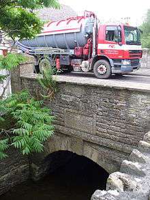
Cricklade Town Bridge is a road bridge at Cricklade, Wiltshire across the River Thames. Formerly it marked the ultimate limit of navigation on the River Thames,[1] but the stretch of the river beyond Lechlade has fallen into disuse and the bridge can only be reached by very small craft.
The bridge is single arch level crossing at the north end of the town. It was built in 1852, there being no previous bridge on the site. The original Cricklade crossing was probably closer to the A419 Bridge where it carried Ermin Way. This road was at some time obliterated at the bend north of the bridge, and a road was deflected from it due south through the town.[2] The River Churn joins the Thames just downstream of the bridge.
See also
References
| Next crossing upstream | River Thames | Next crossing downstream |
| Footbridge at 51°39′5″N 1°52′31″W / 51.65139°N 1.87528°W Midland and South Western Junction Railway bridge |
Cricklade Town Bridge | Cricklade sewage works bridge (no public access) A419 Road Bridge (road) |
This article is issued from
Wikipedia.
The text is licensed under Creative Commons - Attribution - Sharealike.
Additional terms may apply for the media files.