Creston, Iowa
| Creston, Iowa | |
|---|---|
| City | |
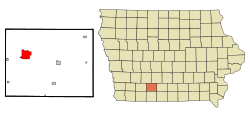 Location of Creston, Iowa | |
| Coordinates: 41°3′33″N 94°21′52″W / 41.05917°N 94.36444°WCoordinates: 41°3′33″N 94°21′52″W / 41.05917°N 94.36444°W[1] | |
| Country |
|
| State |
|
| County | Union |
| Area[2] | |
| • Total | 5.25 sq mi (13.60 km2) |
| • Land | 5.19 sq mi (13.44 km2) |
| • Water | 0.06 sq mi (0.16 km2) |
| Elevation | 1,312 ft (400 m) |
| Population (2010)[3] | |
| • Total | 7,834 |
| • Estimate (2016)[4] | 7,829 |
| • Density | 1,509/sq mi (582.8/km2) |
| Time zone | UTC-6 (Central (CST)) |
| • Summer (DST) | UTC-5 (CDT) |
| ZIP code | 50801 |
| Area code(s) | 641 |
| FIPS code | 19-17265 |
| GNIS feature ID | 0455716 |
| Website | http://www.crestoniowa.gov/ |
Creston is a city in and the county seat of Union County, Iowa, United States.[5] The population was 7,834 at the 2010 census.
History
Creston was originally settled in 1868 as a survey camp for the workers with the Burlington and Missouri Railroad. The campsite was on the crest of the railroad line between the Missouri and Mississippi rivers, hence the name "Creston." The area was developed largely for agriculture, with related industries accompanying it. Creston had a flour mill in the early decades of the 20th century.
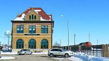
Creston was chosen as the division point for the railroad (now the Burlington Northern-Santa Fe. It built machine shops, roundhouse and a construction camp in the new town. The town was incorporated in 1871. A new railroad station was constructed by the Chicago, Burlington and Quincy Railroad in 1899, and the three-story structure served passengers for 69 years. Workers, including African Americans, were recruited from Chicago and other major cities to work in Creston to maintain the railroad networks. The old machine shop building was destroyed by a tornado in 1946.
Restructuring of railroads in the mid-20th century reduced passenger service to Creston, as railroads had lost passengers to automobile travel and the widespread ownership of vehicles. The number of railroad jobs were reduced in the city, affecting its economy and population. The depot was renovated in 1978 to serve as a City Municipal Building. The remainder of the BNSF roundhouse burned down in 1981, but BNSF continued to be the major hauler of grain and coal in the region. Creston is a stop on the BNSF Railway. Rail crews based in Creston work from Creston to Lincoln, Nebraska, and crews from Galesburg, Illinois and Lincoln stay in town while waiting for trains back to their home terminals.
Today, Amtrak, the national passenger rail system, provides service to Creston. It operates its California Zephyr daily in both directions between Chicago, Illinois, and Emeryville, California, across the bay from San Francisco.[6]
The former Chicago, Burlington and Quincy Railroad depot was adapted to serve as Creston's City Hall. They two-story, yellow-brick structure is in the French Provincial style, with a red-tiled mansard roof.[7]
2012 tornado
On April 14, 2012, the town was hit by a tornado. The tornado was rated an EF2 and caused considerable damage to the hospital, community college, Kingdom Hall of Jehovah's Witnesses and the high school. The town's tornado sirens for some reason did not activate and the tornado caught people off guard. Patients at the hospital were transferred to other local hospitals. The college suffered roof and window damage to its dorms and students were transferred to local hotels for the rest of the school semester. Fourteen people suffered minor injuries, but no deaths occurred.[8] The Greater Regional Medical Center was two weeks from an open house to unveil a major renovation when it was severely damaged by the tornado. One year after the tornado and $10 million in renovations later, the hospital was fully restored.[9]
Geography
Creston is located on U.S. Route 34 in southern Iowa, about 80 miles (130 km) east of Omaha, Nebraska. According to the United States Census Bureau, the city has a total area of 5.25 square miles (13.60 km2), of which, 5.19 square miles (13.44 km2) is land and 0.06 square miles (0.16 km2) is water.[2]
McKinley Lake lies within a large, multi-purpose municipal park within the city limits, and three additional recreational lakes are located within seven miles of Creston: Green Valley State Park, Summit Lake, Twelve Mile Lake and Three Mile Recreation Area.
Demographics
| Historical populations | ||
|---|---|---|
| Year | Pop. | ±% |
| 1870 | 411 | — |
| 1880 | 5,081 | +1136.3% |
| 1890 | 7,200 | +41.7% |
| 1900 | 7,752 | +7.7% |
| 1910 | 6,924 | −10.7% |
| 1920 | 8,034 | +16.0% |
| 1930 | 8,615 | +7.2% |
| 1940 | 8,033 | −6.8% |
| 1950 | 8,317 | +3.5% |
| 1960 | 7,667 | −7.8% |
| 1970 | 8,234 | +7.4% |
| 1980 | 8,429 | +2.4% |
| 1990 | 7,911 | −6.1% |
| 2000 | 7,597 | −4.0% |
| 2010 | 7,834 | +3.1% |
| 2016 | 7,829 | −0.1% |
| Source:"American FactFinder". United States Census Bureau.
and Iowa Data Center Source: | ||
2010 census
As of the census[3] of 2010, there were 7,834 people, 3,378 households, and 1,973 families residing in the city. The population density was 1,509.4 inhabitants per square mile (582.8/km2). There were 3,773 housing units at an average density of 727.0 per square mile (280.7/km2). The racial makeup of the city was 96.0% White, 1.0% African American, 0.3% Native American, 0.6% Asian, 0.8% from other races, and 1.2% from two or more races. Hispanic or Latino of any race were 2.3% of the population.
There were 3,378 households of which 28.1% had children under the age of 18 living with them, 42.5% were married couples living together, 11.5% had a female householder with no husband present, 4.4% had a male householder with no wife present, and 41.6% were non-families. 35.7% of all households were made up of individuals and 15.3% had someone living alone who was 65 years of age or older. The average household size was 2.23 and the average family size was 2.87.
The median age in the city was 38.8 years. 23.1% of residents were under the age of 18; 10.5% were between the ages of 18 and 24; 22.9% were from 25 to 44; 25.5% were from 45 to 64; and 17.9% were 65 years of age or older. The gender makeup of the city was 47.7% male and 52.3% female.
2000 census
As of the census[11] of 2000, there were 7,597 people, 3,346 households, and 1,974 families residing in the city. The population density was 1,496.2 people per square mile (577.4/km2). There were 3,598 housing units at an average density of 708.6 per square mile (273.5/km2). The racial makeup of the city was 98.13% White, 0.34% African American, 0.22% Native American, 0.34% Asian, 0.38% from other races, and 0.58% from two or more races. Hispanic or Latino of any race were 1.26% of the population.
There were 3,346 households out of which 26.4% had children under the age of 18 living with them, 46.5% were married couples living together, 9.9% had a female householder with no husband present, and 41.0% were non-families. 35.7% of all households were made up of individuals and 16.0% had someone living alone who was 65 years of age or older. The average household size was 2.20 and the average family size was 2.86.
Age spread: 22.6% under the age of 18, 10.4% from 18 to 24, 25.0% from 25 to 44, 22.0% from 45 to 64, and 20.0% who were 65 years of age or older. The median age was 39 years. For every 100 females, there were 86.7 males. For every 100 females age 18 and over, there were 83.3 males.
The median income for a household in the city was $29,831, and the median income for a family was $41,003. Males had a median income of $27,580 versus $20,172 for females. The per capita income for the city was $16,411. About 7.0% of families and 11.5% of the population were below the poverty line, including 13.6% of those under age 18 and 8.3% of those age 65 or over.
Education
Creston is served by the Creston Community School District:[12]
- Creston High School
- Creston Middle School
- Creston Elementary School
Private Schools in Creston include:
- St. Malachy School (K-8)
- Mayflower Heritage Christian Academy (K-8)
Colleges
- Southwestern Community College
- Buena Vista University - Creston Campus
Notable people
- Harry Archer, Broadway composer and bandleader
- William Bell, tubist
- Julee Cruise, actress and singer
- Walter Cunningham (born 1932) astronaut on the Apollo 7 mission[13]
- Sherry Edmundson Fry, sculptor and co-founder of the American Army Camouflage Corps
- Dick Wick Hall, writer and humorist
- Jerry Harrington, Major League Baseball player
- Bob Hawk, radio personality
- Jerome C. Hunsaker (1886–1984), designer of flying boats and airships
- James M. McCoy, Chief Master Sergeant in the United States Air Force.
- Edward E. Miller, U.S. Representative from Illinois
- Frosty Peters, American football player
- Frank Phillips, founder of the Phillips Petroleum Company
- Amy Higgins, screenwriter
- John JR Robinson (born 1954), one of the most recorded drummers in history[14]
- Phyllis Thede (born 1954), lived here as a child; since 2009 she has served as an Iowa state representative
- Marcia Wallace (1942–2013), actress
References
- ↑ "US Gazetteer files: 2010, 2000, and 1990". United States Census Bureau. 2011-02-12. Retrieved 2011-04-23.
- 1 2 "US Gazetteer files 2010". United States Census Bureau. Archived from the original on 2012-01-24. Retrieved 2012-05-11.
- 1 2 "American FactFinder". United States Census Bureau. Retrieved 2012-05-11.
- ↑ "Population and Housing Unit Estimates". Retrieved June 9, 2017.
- ↑ "Find a County". National Association of Counties. Archived from the original on 2011-05-31. Retrieved 2011-06-07.
- ↑ , Amtrak
- ↑ "City Hall", Creston, Iowa website
- ↑ "Storm hits Iowa hospital; tornado warning issued for Wichita". CNN. April 15, 2012.
- ↑ "GRMC Responds, Recovers from Tornado with community support", Creston News-Advertiser, 12 April 2013
- ↑ "Census of Population and Housing". Census.gov. Archived from the original on May 12, 2015. Retrieved June 4, 2015.
- ↑ "American FactFinder". United States Census Bureau. Archived from the original on 2013-09-11. Retrieved 2008-01-31.
- ↑ "Creston." Iowa Department of Education. Retrieved on July 30, 2018.
- ↑ "Walter Cunningham NASA Astronaut(former)". NASA. Retrieved 2011-09-10.
- ↑ "John JR Robinson". DRUMMERWORLD. Retrieved 2011-09-10.
External links
| Wikimedia Commons has media related to Creston, Iowa. |
- Creston City Website
- Union County Website
- Union County Development Association
- Creston Iowa Information
- Creston News Advertiser
- Creston Community School District
- Greater Regional Medical Center
- City Data Comprehensive Statistical Data and more about Creston
- Southern Prairie YMCA
- Creston:Arts
- Crest Area Theatre
- Creston Apartments and Rentals
- Iowa Jobs
- Iowa Workforce Development
- http://www.loc.gov/pictures/resource/ds.05207/?co=pan
Municipalities and communities of Union County, Iowa, United States | ||
|---|---|---|
| Cities | ||
| CDP | ||
| Unincorporated communities | ||
| Footnotes | ‡This populated place also has portions in an adjacent county or counties | |