Crail
Crail
| |
|---|---|
 | |
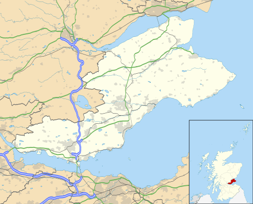 Crail Crail shown within Fife | |
| Population | 1,639 [2] |
| OS grid reference | NO613078 |
| Council area | |
| Lieutenancy area | |
| Country | Scotland |
| Sovereign state | United Kingdom |
| Post town | ANSTRUTHER. |
| Postcode district | KY10 |
| Dialling code | 01333 |
| Police | Scottish |
| Fire | Scottish |
| Ambulance | Scottish |
| EU Parliament | Scotland |
| UK Parliament | |
| Scottish Parliament | |
Crail (![]()
The civil parish has a population of 1,812 (in 2011).[3]
History
Crail probably dates from at least as far back as the Pictish period, as the place-name includes the Pictish/Brythonic element caer, 'fort'. According to Crail Parish Church's website (see external link below), the site on which the parish church is built appears to have religious associations that pre-date the parish church's foundation in early mediaeval times, as evidenced by a Dark Age cross-slab preserved in the church. The parish church was itself dedicated (in the 13th-century) to the early holy man St. Maelrubha of Applecross in Wester Ross.
Crail became a Royal Burgh in 1178 in the reign of King William the Lion.[4] Robert the Bruce granted permission to hold markets on a Sunday, in the Marketgait, where the Mercat Cross now stands in Crail. This practice was still continuing in the 16th century, causing concern in the freshly puritanical circles of Edinburgh such that John Knox, visiting Crail on his way to St Andrews in 1559, was moved to deliver a sermon in Crail Parish Church, damning the fishermen of the East Neuk for working on a Sunday. (See Crail Parish Church website: external link below.) Despite the protests, the markets continued and were amongst the largest in Europe for their time.[5]
James V (the father of Mary Queen of Scots) sent for his wife, Mary of Guise, whom he had recently married by proxy in Paris, and she landed in Crail in June 1538. According to Antonia Fraser, "Accompanied by a navy of ships under Lord Maxwell, and 2,000 lords and barons whom her new husband had sent from Scotland to fetch her away, Queen Mary landed at Crail in Fife on 10 June 1538, just over a year since the landing of Queen Madeleine. She was formally received by the king at St Andrews a few days later with pageants and plays performed in her honour, and a great deal of generally blithe rejoicing, before being remarried the next morning in the Cathedral of St Andrews."[6] (Queen Madeleine, the first wife of James V, had landed at Leith in the spring of 1537 and died shortly afterwards.)
Architecture

Built around a harbour, Crail has a particular wealth of vernacular buildings from the 17th to early 19th centuries, many restored by the National Trust for Scotland, and is a favourite subject for artists.
The most notable building in the town is the parish church, situated in the Marketgate - from the mid 13th century St Maelrubha's, in later medieval times St Mary's, but now, as part of the Church of Scotland's ministry, known just as Crail Parish Church. According to Crail Parish Church's website (see external link below) it was founded in the second half of the 12th century. From early in its history it belonged to the Cistercian Nunnery of St Clare in Haddington and remained the Nunnery's possession until the Reformation.
Though much altered, this is one of Scotland's most beautiful ancient churches. According to Crail Parish Church's website (see external link below) in its first form the church building consisted of an unaisled rectangular nave and chancel of romanesque design. In the early 13th century a fine western tower with small spire was added, and a double arcade of round pillars of variegated red sandstone in the nave. It was in this form in 1243 that the church was dedicated to St Maelrubha by the Bishop of St Andrews. (In later times it was known as St Mary's probably after a later dedication in a later period that disliked vestiges of the Celtic Church.) The side walls were rebuilt in Regency times, and the large pointed windows, filled with panes of clear glass held by astragals rather than leads, allow light to flood into the interior. The unaisled chancel, now housing a huge organ, has been shortened. The church retains some 17th-century woodwork. The early Christian cross-slab mentioned at the start of this article is on display in the church: it is of unusual form (perhaps 10th century), formerly set in the floor. The church building is open on some afternoons in the summer.
The large Kirkyard surrounding the building has a fine collection of monuments and stones dating from the late 16th century onwards.
Other historic buildings in Crail include the doo'cot (Scots for dovecot) of the town's otherwise vanished Franciscan Friary.
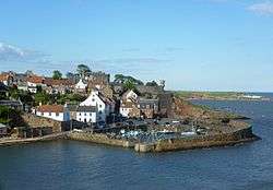
Crail once had a royal castle above the harbour (perhaps this was the site of the 'fort'). The site is still visible as an open garden attached, but little or nothing of the structure survives above ground. A Victorian 'turret' jutting out from the garden wall recalls the Castle (visible in the photograph reproduced above).
The Tolbooth is near the juncture of Tolbooth Wynd and the Marketgate. It stands on its own at the edge of the large marketplace with its mercat cross in the centre of the town - this is where the Sunday markets were once held. (The former marketplace is now used as a car park.) The Tolbooth has a characteristic tower dating from about 1600 and a European style roof, similar to buildings in Holland. The weathervane on the spire is in the form of a smoked haddock (known locally as a Crail Capon) rather than the traditional cockerel form.[7] The curved roof form on the tower evidences the European influence of the 16th century, and is architecturally described as a Dutch spire (several other contemporary examples exist in Scotland). The bell inside was cast in Holland and bears the date 1520, and is a permanent reminder of the town’s trading links with the Dutch.
The Crail Museum and Heritage Centre, largely staffed by volunteers and open every day in summer, is sited in a neighbouring building, also of historical interest, at the top of Tolbooth Wynd. (See external link below.) It houses temporary exhibitions and has a permanent exhibition on HMS Jackdaw. On permanent display in the Burgh Room is the ceremonial robe worn by the provost of the Burgh of Crail before the reorganisation of local government in Scotland in 1975. (Before 1975 each Scottish burgh was governed by a town council headed by a provost.) Entry to Crail Museum is free but donations are accepted. On Sunday afternoons in summer the museum is the leaving point for guided tours of Crail, led by volunteer guides.
A branch of Fife Council's library service, open part time, occupies the Tolbooth, but (as of 2017) the branch is threatened with closure for economic reasons [5]
The Customs House on the Shoregate dates from the 17th century.
The harbour is known to have been substantially complete by 1583. The extension of 1828 to the west pier of Crail Harbour is the work of Robert Stevenson.[8]
Notable residents
- James Oswald (composer) (1710-1769)
- William Dickson, footballer (1866-1910)
- Oswald Wynd, Author (1913–1998)
- Joan Clarke, cryptlanyst and former fiancée of Alan Turing
Carboniferous fossils
On the beach beside the harbour, there are fossilised trees related to Horsetails, dating back to the Carboniferous geological period.
Sport
The Crail Golfing Society is the seventh oldest in the world, formed in 1786. Their oldest course, Balcomie, was formally laid out by Tom Morris Sr. in 1894, but competitions had been played there since the 1850s. Despite the fact that the ‘home’ of golf is now Crail’s neighbour, St Andrews, Crail was the first to have a golf course.
Aerodrome
Crail Aerodrome, to the north of the town, started life as a naval air station during the First World War. In the runup to the Second World War it became HMS Jackdaw. Polish soldiers stationed at Crail during the Second World War helped the Archdiocese of St Andrews and Edinburgh purchase the disused United Presbyterian Church (built 1859). In 1942, it became the Most Holy Trinity Church. The Church has recently been renovated and contains an icon to Our Lady of Poland painted by one of the Polish soldiers.
After the war, the airfield was taken over by the Royal Navy and renamed HMS Bruce. After closure, the Joint Services School for Linguists (JSSL) was based here in the 1950s. JSSL was founded in 1951 by the British armed services to provide language training, principally in Russian, and largely to selected conscripts undergoing National Service. It was initially located at three main sites near Bodmin, Caterham and Cambridge, run respectively by the Army, Navy and RAF. In 1956 the three were amalgamated at Crail. The school closed with the ending of conscription in 1960. It had many famous alumni.
The airfield site now is home to Crail Raceway. It hosts events every second Sunday of the month, and lets drivers compete with their own vehicles. Most commonly drag racing as been at the core of the Raceway's activities throughout its life, but especially in more recent years drifting has become an attraction at this track.
Gallery
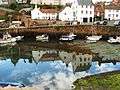 Crail Harbour
 House near the harbour
 Crail Harbour
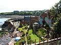 Viewing the harbour from above
 Boats in Crail Harbour
References
- ↑ Iomart Cholm Cille
- ↑ "Mid-2008 Population Estimates – Localities in order of size". General Register Office for Scotland. 2008. Archived from the original on 2 July 2010. Retrieved 2010-09-08.
- ↑ Census of Scotland 2011, Table KS101SC – Usually Resident Population, publ. by National Records of Scotland. Web site http://www.scotlandscensus.gov.uk/ retrieved March 2016. See “Standard Outputs”, Table KS101SC, Area type: Civil Parish 1930
- ↑ Scottish Seaside Towns, by Brian Edwards ISBN 0-563-20452-4
- 1 2 "East Neuk of Fife". BBC. Retrieved 29 May 2012.
- ↑ Mary Queen of Scots, Antonia Fraser, Weidenfeld & Nicolson, 1969.
- ↑ Scottish Seaside Towns, by Brian Edwards ISBN 0-563-20452-4
- ↑ Scottish Seaside Towns, by Brian Edwards ISBN 0-563-20452-4
External links
| Wikimedia Commons has media related to Crail. |
- Crail Parish Church
- The Golf Hotel - one of Scotland's oldest coaching inns
- Crail Pottery
- Crail Museum & Heritage Centre
- Crail Golfing Society
- History of Crail Timeline
- Crail Raceway
- The Crail Gallery
- The Jerdan Gallery
- Crail Harbour Gallery & Tearoom
- Julias Cafe & Gifts
- Honeypot Guest Rooms & Coffee House
- Longskerries Holiday Cottage
| Authority control |
|---|