Cove Orchard, Oregon
| Cove Orchard | |
|---|---|
| Unincorporated community | |
 Pentecostal Church in Cove Orchard | |
 Cove Orchard Location within the state of Oregon  Cove Orchard Cove Orchard (the US) | |
| Coordinates: 45°22′30″N 123°09′17″W / 45.37500°N 123.15472°WCoordinates: 45°22′30″N 123°09′17″W / 45.37500°N 123.15472°W | |
| Country | United States |
| State | Oregon |
| County | Yamhill |
| Elevation | 259 ft (79 m) |
| Time zone | UTC-8 (Pacific (PST)) |
| • Summer (DST) | UTC-7 (PDT) |
| GNIS feature ID | 1162920[1] |
| Coordinates and elevation from Geographic Names Information System[1] | |
Cove Orchard is an unincorporated community in Yamhill County, in the U.S. state of Oregon. It is along Oregon Route 47 between Yamhill and Gaston in the northern part of the county.[2]
According to Oregon Geographic Names, F. C. Graham of Portland platted the community and chose the name. Cove Orchard had a post office from 1912 to 1953.[3]
References
- 1 2 "Cove Orchard". Geographic Names Information System. United States Geological Survey. November 28, 1980. Retrieved December 16, 2016.
- ↑ Oregon Atlas & Gazetteer (7th ed.). Yarmouth, Maine: DeLorme. 2008. p. 27. ISBN 0-89933-347-8.
- ↑ McArthur, Lewis A.; Lewis L. McArthur (2003) [1928]. Oregon Geographic Names (7th ed.). Portland, Oregon: Oregon Historical Society Press. p. 240. ISBN 0-87595-277-1.
Municipalities and communities of Yamhill County, Oregon, United States | ||
|---|---|---|
| Cities | 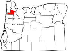 | |
| CDPs | ||
| Other unincorporated communities | ||
| Indian reservation | ||
| Footnotes | ‡This populated place also has portions in an adjacent county or counties | |
This article is issued from
Wikipedia.
The text is licensed under Creative Commons - Attribution - Sharealike.
Additional terms may apply for the media files.