Ross and Cromarty
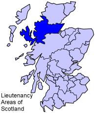
lieutenancy area (1996–present)
county (1889–1975)
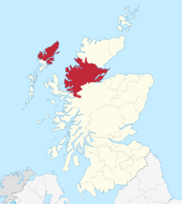
Ross and Cromarty (Scottish Gaelic: Ros agus Cromba) is a variously defined area in the Highlands and Islands of Scotland. There is a registration county and a lieutenancy area in current use, the latter of which is 8,019 square kilometres (3,096 square miles) in extent. Historically there has also been a constituency of the Parliament of the United Kingdom (1832 to 1983), a local government county (1890 to 1975), a district of the Highland local government region (1975 to 1996) and a management area of the Highland Council (1996 to 2007). The local government county is now divided between two local government areas: the Highland area and Na h-Eileanan Siar (the Western Isles).
The county was formed by the uniting of the shires of Ross-shire and Cromartyshire. Both these shires had themselves been formed from the historic province of Ross, out of which the many exclaves that formed Cromartyshire were carved out, leaving the remaining portions to become Ross-shire.[1] These exclaves were for many purposes administered as part of Ross-shire rather than Cromartyshire.[1][2][3] The county also included the Isle of Lewis, however this is not part of the modern lieutenancy area (which instead includes the Isle of Skye), although Lewis is part of the current registration county.
Description of the area
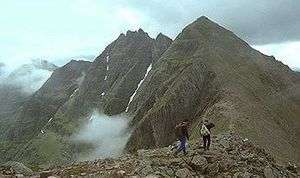
Ross is traditionally divided in Easter Ross and Wester Ross. Wester Ross is well known for its mountain scenery, especially the Torridon Hills which includes such peaks as Beinn Eighe and Liathach, composed of some of the oldest rock formations in Europe. The rocks are of Cambrian and Precambrian age. Easter Ross is less mountainous, and consists of towns, villages and farmland bordering the Moray Firth. Lewis is the northern part of Lewis and Harris, the largest island of the Western Isles, and is, in general, the lower-lying part of the island. Due to its flatter, more fertile land, Lewis contains three-quarters of the population of the Western Isles, and the largest settlement, Stornoway.
The main economic activities in Ross and Cromarty are crofting, fishing and tourism. The population as of 2001 was 49,967.[4]
Parliamentary constituency
The name Ross and Cromarty was first used for the Ross and Cromarty county constituency of the Parliament of the United Kingdom from 1832 to 1983. As created in 1832, the constituency merged two former county constituencies: the Ross-shire constituency and the Cromartyshire constituency, and it elected a Member of Parliament to represent the counties of Ross-shire and Cromartyshire, minus their parliamentary burghs, Dingwall, Tain and Fortrose, which were represented as components of the Wick burghs constituency and the Inverness burghs constituency.
Constituency boundaries were altered in 1918, by the Representation of the People Act 1918, and the Ross and Cromarty constituency acquired the boundaries of the county of Ross and Cromarty, including the former parliamentary burghs, but minus Stornoway and Lewis, which became part of a new constituency, the Western Isles constituency.
In 1983, the Ross, Cromarty and Skye constituency was created to represent the then Ross and Cromarty district and Skye and Lochalsh district. The Kincardine area joined the Caithness and Sutherland constituency.
Local government
County
The local government county of Ross and Cromarty was created in 1890 under the Local Government (Scotland) Act 1889, with boundaries similar to, but not exactly the same as, the boundaries of the constituency. The county continued with largely unchanged boundaries until its abolition in 1975.
When the county was abolished in 1975, the mainland part became part of the new Highland Region, and Lewis became part of the Western Isles islands area.
District
In 1975 the mainland part of the former county was effectively divided between three districts of the Highland region. Most of the former county became the new district of Ross and Cromarty. The Lochalsh area joined the Skye and Lochalsh district and the Kincardine area joined the Sutherland district. The district was abolished in 1996.
Since 1996
The wards in the former district of Ross and Cromarty formed the management area of Ross and Cromarty from 1996 to 1999, and again from 1999 to 2007. The name was not used for a management area after 2007.
Registration county
The registration county of Ross and Cromarty, used for land registry purposes, covers the area of the former county of Ross and Cromarty, including Lewis.[5]
Lieutenancy area
Lieutenancy areas are subdivisions used for the ceremonial lord lieutenants, the monarch's representatives. The Ross and Cromarty lieutenancy area combines the areas of two former districts of the Highland region: Ross and Cromarty, and Skye and Lochalsh. The area therefore includes the mainland part of the registration county and former administrative county of Ross and Cromarty, excluding Kincardine, with the addition of the Isle of Skye, which is in the registration county (and former administrative county) of Inverness-shire.
See also
References
- 1 2 Mackenzie 1810, pp.15–16
- ↑ Her Majesty’s Law Commissioners, Scotland (1839). "Appendix; Return by John Jardine, Esq., Sheriff of Ross and Cromarty". Fourth Report. Command papers. C 241. p. 186.
- ↑ Ordnance Gazetteer of Scotland, Vol.2 p.310–1, Cromartyshire
- ↑ "ROSS AND CROMARTY: The Area of Ross and Cromarty in Scotland". British-towns.net. 2017-07-15. Retrieved 2017-07-24.
- ↑ "Map of Land Register counties" (PDF). Ros.gov.uk. Archived from the original (PDF) on 2013-09-28. Retrieved 2017-07-24.
Further reading
- D. Alston, Ross and Cromarty : a historical guide (Edinburgh : Birlinn, 1999 ISBN 1-874744-48-3), which, however, restricts itself to coverage of the mainland county;
- R. Bain, History of the Ancient Province of Ross (Dingwall, 1899);
- J. H. Dixon, Gairloch (Edinburgh, 1888);
- F. N. Reid, The Earls of Ross (Edinburgh, 1894);
- W. C. Mackenzie, History of the Outer Hebrides (Paisley, 1904).
External links
| Wikimedia Commons has media related to Ross and Cromarty. |