Corney
| Corney | |
|---|---|
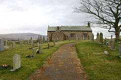 St John's Church, Corney | |
 Corney Corney shown within Cumbria | |
| OS grid reference | SD1191 |
| Civil parish |
|
| District | |
| Shire county | |
| Region | |
| Country | England |
| Sovereign state | United Kingdom |
| Post town | MILLOM |
| Postcode district | LA19 |
| Dialling code | 01229 |
| Police | Cumbria |
| Fire | Cumbria |
| Ambulance | North West |
| EU Parliament | North West England |
| UK Parliament | |
Corney is a small settlement in Cumbria, England and located in the west of the Lake District. It is near the A595 road, in the civil parish of Waberthwaite and Corney and it is located north east of Bootle and is 10 miles north of Millom. The name is well known to travellers who take the fell road from Duddon Bridge to Ravenglass, as this route is known as the "Corney Fell Road". It is possible to see the Isle of Man, North Wales and parts of Scotland from Corney on a clear day.
Corney is home to a predominantly agricultural community. Corney is also close to the ruins of a 12th-century Benedictine nunnery (no public access).[1] St John's Church dates back to as early as the 12th century.[2]
Corney, coincidentally, is almost exactly located at the South West Corner of The British Geological Survey, 1:50,000 Geological Sheet 38 (England and Wales). Corney is underlain by Grandiorite of the Eskdale intrusion, intruded during the Ordovician period.[3]
See also
References
- ↑ "British Listed Buildings".
- ↑ "Visit Cumbria".
- ↑ B.G.S. Geology of the Ambleside District. ISBN 0118845470
External links
| Wikimedia Commons has media related to Corney. |