Cope, Colorado
| Cope, Colorado | |
|---|---|
| Unincorporated community | |
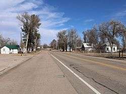 U.S. Route 36 in Cope. | |
 Cope, Colorado Location within the state of Colorado | |
| Coordinates: 39°39′49″N 102°51′08″W / 39.66361°N 102.85222°WCoordinates: 39°39′49″N 102°51′08″W / 39.66361°N 102.85222°W | |
| Country |
|
| State |
|
| County | Washington County[1] |
| Elevation[1] | 4,406 ft (1,343 m) |
| Time zone | UTC-7 (MST) |
| • Summer (DST) | UTC-6 (MDT) |
| ZIP Code[2] | 80812 |
Cope is an unincorporated community and U.S. Post Office in Washington County, Colorado, United States. The Cope Post Office has the ZIP Code 80812.[2]
A post office called Cope has been in operation since 1889.[3] The community was named after Johnathon C. Cope, a railroad official.[4]
Geography
Cope is located at 39°39′49″N 102°51′08″W / 39.66361°N 102.85222°W (39.663592,-102.852116).
See also
References
- 1 2 "US Board on Geographic Names". United States Geological Survey. 2007-10-25. Retrieved 2008-01-31.
- 1 2 "ZIP Code Lookup". United States Postal Service. December 15, 2006. Archived from the original (JavaScript/HTML) on September 3, 2007. Retrieved December 15, 2006.
- ↑ "Post offices". Jim Forte Postal History. Archived from the original on 6 March 2016. Retrieved 25 June 2016.
- ↑ Dawson, John Frank. Place names in Colorado: why 700 communities were so named, 150 of Spanish or Indian origin. Denver, CO: The J. Frank Dawson Publishing Co. p. 15.
Municipalities and communities of Washington County, Colorado, United States | ||
|---|---|---|
| Towns | 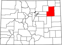 | |
| Unincorporated communities | ||
| Ghost town | ||
This article is issued from
Wikipedia.
The text is licensed under Creative Commons - Attribution - Sharealike.
Additional terms may apply for the media files.