Cooks Creek (Delaware River)
| Cooks Creek | |
|---|---|
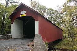 Knecht's Covered Bridge, September 2012 | |
 Cooks Creek | |
| Other name(s) | Cook Creek, Durham Creek, Schooks Creek, Scookes Creek, Scooks Creek, Squooks Creek |
| Country | United States |
| State | Pennsylvania |
| County | Bucks |
| Township | Springfield |
| Township | Durham |
| Physical characteristics | |
| Main source |
750 feet (230 m) 40°31′25″N 75°20′17″W / 40.52361°N 75.33806°W |
| River mouth |
141 feet (43 m) 40°34′48″N 75°11′48″W / 40.58000°N 75.19667°WCoordinates: 40°34′48″N 75°11′48″W / 40.58000°N 75.19667°W |
| Length | 13 miles (21 km) |
| Basin features | |
| Progression | Cooks Creek → Delaware River |
| River system | Delaware River |
| Basin size | 29.50 square miles (76.4 km2) |
| Tributaries |
|
| Bridges |
Passer Road State Road Richlandtown Pike Funks Mill Road Pennsylvania Route 212 (Durham Road) Molasses Way Bridge Street Old Bethlehem Road Shale Road Township Road Knecht Bridge Road Slifer Valley Road Pennsylvania Route 412 (Durham Road) Durham Road Stouts Valley Road Pennsylvania Route 611 (Easton Road) |
| Slope | 46.85 feet per mile (8.873 m/km) |
Cooks Creek (Cook Creek, Durham Creek, Schooks Creek, Scookes Creek, Scooks Creek, Squooks Creek) is a tributary of the Delaware River in Bucks County, Pennsylvania, in the United States, rising in Springfield Township and passing through Durham Township before emptying into the Pennsylvania Canal (Delaware Division) and the Delaware.
History
Cooks Creek was thought by historian Edward Mathews to have been named after Arthur Cooke, a landowner in the area (though not a resident) in this part of the county before 1700, but, there is doubt about this. In a deed executed on 10 February 1727 between Samuel Powell, Jeremiah Langhorne, and others of Philadelphia for tracts of land in Durham Township, the stream was referred to as Scooks Creek and the modern name may have been derived from that. The Creek was a major source of power for the Durham Mill and Furnace and a water supply to the Canal. In the 1940s, the creek was the only creek in Bucks County in which brook trout (Salvelinus fontinalis) was native.[1]Knecht's Mill Covered Bridge was entered into the National Register of Historic Places on 1 December 1980 as reference number 80003432.[2]
Statistics
Cooks Creek was entered into the Geographic Names Information System of the U.S. Geological Survey on 2 August 1979 as identification number 1172390. In the Pennsylvanea Gezatteer of Streams, its identification number is 03295. It rises in Springfield Township about halfway between Coopersburg and Pleasant Valley at an elevation of 750 feet (230 m) and empties into the Pennsylvania Canal (Delaware Division) and into the Delaware River about 0.7 miles (1.1 km) downstream of Reigelsville at an elevation of 141 feet (43 m) after having flowed 13 miles (21 km). This results in an average slope of 46.85 feet per mile (8.873 m/km).[3][4]
Course
Cooks Creek rises in Springfield Township just west of Richlandtown Pike about halfway between Coopersburg and Pleasant Valley flowing to the southeast until it passes under Pennsylvania Route 212 where it turns to the northeast until it reaches the western slope of Cressman Hill where it turns north until it runs by the eastern end of Springtown, then turns northeast. As it approaches the north slope of Mine Hill, it receives Hollow Run from the right bank. Then lastly, it skirts around the north slope of Rattlesnake Hill then empties into the [[Pennsylvania Canal (Delaware Division), then finally into the] Delaware River. Besides Hollow Run, it receives five tributaries from the left and three from the right.[5]
Geology
Cooks Creek starts out on Flint Hill in the Quartz Fanglomerate laid down during the Jurassic and Triassic, consisting of Quartz conglomerate with round cobbles and boulders of quartzite, sandstone, quartz, and metahyolite in red sand.
Then it passes through a region of Brunswick Formation, also formed during the Jurassic and Triassic, consisting of mudstone, siltstone, and shale. Mineralogy includes argillite and hornfel.
Later, it flows through a region of the Leithsville Formation, from the Cambrian, consisting of dolomite, calcareous shale, and chert.
In two places, it briefly touches beds of he Hardyston Quartzite formation, from the Canbrian, containing quartzite, feldspathic sandstone and has quartz-pebble conglomerate.
Finally, it lies upon a region of the Allentown Formation, from the Cambrian, which contains dolomite, limestone, chert, siltstone, and some oolites, stromatolites, and sharpstone conglomerate.[6]
Crossings and Bridges
| Crossing | NBI Number | Length | Lanes | Spans | Material/Design | Built | Reconstructed | Latitude | Longitude |
|---|---|---|---|---|---|---|---|---|---|
| Passer Road | - | - | - | - | - | - | - | - | |
| State Road | - | - | - | - | - | - | - | - | - |
| Richlandtown Pike | - | - | - | - | - | - | - | - | - |
| Funks Mill Road | - | - | - | - | - | - | - | - | - |
| Pennsylvania Route 212 (Quakertown Road) | 6938 | 7 metres (23 ft) | 2 | 1 | Concrete Tee Beam | 1924 | - | 40°29'48"N | 75°18'36"W |
| Molasses Way | - | - | - | - | - | - | - | - | - |
| Bridge Street | 7583 | 17 metres (56 ft) | 1 | 1 | Steel Truss - Thru | - | 1950 | 40°30'58"N | 75°17'33"W |
| Old Bethlehem Road | 7472 | 17 metres (56 ft) | 2 | 3 | Masonry Arch-deck | 1902 | - | 40°31'2"N | 75°17'29.61"W |
| Shale Road | - | - | - | - | - | - | - | - | - |
| Township road | 7585 | 26 metres (85 ft) | 2 | 1 | Prestressed concrete Box Beam or Girders - Single or Spread | 1961 | 2014 | 40°31'29.9"N | 75°16'32.4"W |
| Kecht Bridge Road (Knecht's Mill Covered Bridge) | 7554 | 34 metres (112 ft) | 1 | 1 | Wood or Timber Truss -Thru (covered bridge) | - | 1983 | 40°32'17.6"N | 75°16'40.8"W |
| Slifer Valley Road | 7444 | 16 metres (52 ft) | 2 | 1 | Steel Stringer/Multi-beam or Girder | 1953 | - | 40°32'33.7"N | 75°16'27.72"W |
| Pennsylvania Route 412 (Durham Road, Hellertown Road) | 48227 | 8 metres (26 ft) | 2 | 1 | Concrete Culvert | 2013 | - | 40°32'48"N | 75°18'12"W |
| Durham Road | 7454 | 15 metres (49 ft) | 2 | 2 | Concrete Tee Beam | 1925 | - | 40°34'36.5"N | 75°13'28.75"W |
| Stouts Valley Road | 7565 | 29 metres (95 ft) | 2 | 2 | Concrete Tee Beam | 1931 | - | 40°35'11.5"N | 75°12'39.8"W |
| Pennsylvania Route 611 (Easton Road, River Road) | 7088 | 22 metres (72 ft) | 2 | 1 | Prestressed concrete Box Beam or Girders - Multiple | 1959 | - | 40°34'47.9"N | 75°11'49.8"W |
See also
References
- ↑ MacReynolds, George, Place Names in Bucks County, Pennsylvania, Doylestown, Bucks County Historical Society, Doylestown, PA, 1942, P82.
- ↑ "National Historic Landmarks & National Register of Historic Places in Pennsylvania" (Searchable database). CRGIS: Cultural Resources Geographic Information System. Note: This includes Susan M. Zacher (n.d.). "National Register of Historic Places Inventory Nomination Form: Knecht's Mill Covered Bridge" (PDF). Retrieved 2012-10-29.
- ↑ U.S. Geological Survey Geographic Names Information System: Cooks Creek
- ↑ paGazetteerOfStreams, lycomingedu, p48, I.D. 03295 (PDF)
- ↑ "GNIS Feature Search". TNM download. U.S. Geological Survey, U.S. Department of the Interior. Retrieved 30 January 2018.
- ↑ "Pennsylvania Geological Survey". PaGEODE. Pennsylvania Department of Conservation and Natural Resources. Retrieved 14 October 2017.
- ↑ http://www.nationalbridges.com/, retrieved 30 January 2018.