Connecticut Route 117
| ||||
|---|---|---|---|---|
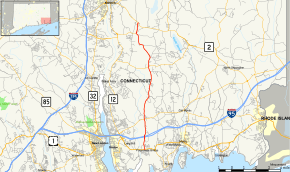 Map of New London County in southeastern Connecticut with Route 117 highlighted in red | ||||
| Route information | ||||
| Maintained by ConnDOT | ||||
| Length | 11.32 mi[1] (18.22 km) | |||
| Existed | 1963 – present | |||
| Major junctions | ||||
| South end |
| |||
|
| ||||
| North end |
| |||
| Location | ||||
| Counties | New London | |||
| Highway system | ||||
| ||||

Route 117 is a state highway in southeastern Connecticut, running from Groton to Preston. Route 117 is designated the Colonel Ledyard Highway from its intersection with Route 184 in Groton to the Ledyard-Preston town line.[1]
Route description
Route 117 begins at an intersection with US 1 in the village of Poquonnock Bridge in Groton. It starts out as Newtown Road then changes to North Road. About a mile north of US 1, Route 117 has an interchange with I-95 (Exit 88), then continues northward towards the village of Center Groton, where it meets Route 184. There is also access to the Star Plaza shopping area near this junction. Route 117 then enters the town of Ledyard as Center Groton Road. It intersects with Route 214 in Ledyard Center then continues north for another 3.2 miles (5.1 km) until the town line with Preston. In Preston, the road becomes known as Hallville-Poquetanuck Road. Just north of the town line it meets Route 2A which joins Route 117 as they head north towards Route 2 in the village of Hallville. Immediately after crossing Indiantown Brook, Routes 117 and 2A end at Route 2.[1]
History
Since the 1930s, the road between Center Groton and Ledyard center was an unsigned state road known as SR 588. In 1959, SR 588 was extended north using the Colonel Ledyard Highway to the village of Poquetanuck. Route 117 was established in 1963 as part of the 1962 Route Reclassification Act as a redesignation of old SR 588. One year later, the Route 117 designation was extended south to US 1 using a newly constructed extension of North Road. A portion of the current route in Ledyard used to be an old alignment of Route 27.[2]
Junction list
The entire route is in New London County.
| Location | mi[1] | km | Destinations | Notes | |
|---|---|---|---|---|---|
| Groton | 0.00 | 0.00 | |||
| 1.07 | 1.72 | Exit 88 (I-95) | |||
| 2.56 | 4.12 | ||||
| Ledyard | 7.12 | 11.46 | |||
| Preston | 10.45 | 16.82 | Western terminus of CT 2A overlap | ||
| 11.32 | 18.22 | Eastern terminus of CT 2A overlap; northern terminus of CT 117 (eastern terminus of CT 2A) | |||
1.000 mi = 1.609 km; 1.000 km = 0.621 mi
| |||||
References
- 1 2 3 4 Connecticut State Highway Log Archived 2015-07-26 at WebCite
- ↑ Connecticut Routes, Route 117
External links
Route map: