Colsterdale
| Colsterdale | |
|---|---|
 Colsterdale Colsterdale shown within North Yorkshire | |
| OS grid reference | SE130813 |
| Civil parish |
|
| District | |
| Shire county | |
| Region | |
| Country | England |
| Sovereign state | United Kingdom |
| Post town | RIPON |
| Postcode district | HG4 |
| Police | North Yorkshire |
| Fire | North Yorkshire |
| Ambulance | Yorkshire |
| EU Parliament | Yorkshire and the Humber |
Colsterdale is the valley of the River Burn, a tributary of the River Ure, in the Yorkshire Dales in North Yorkshire, England. It gives its name to a hamlet and civil parish in the upper part of the dale, about 7 miles (11 km) west of Masham. The population of the civil parish was estimated at 20 in 2010.[1] The lower part of the dale is in the civil parish of Healey. The area is in Harrogate district.
Although Colsterdale is not in Nidderdale, it lies within the Nidderdale Area of Outstanding Natural Beauty.
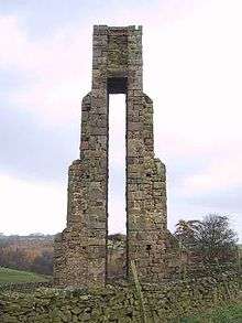
The Colsterdale towers are towers built between 1895 and 1911 to conduct surveys.
History
The name, first recorded in 1281, means "coalman valley". There was a coal mine here in the 14th century.[2]
Colsterdale was historically divided between the parishes of East Witton and Masham in the North Riding of Yorkshire.[3] In the 19th century the upper part of the dale, above Gollinglith Foot, became part of the civil parish of East Witton Without, but in 1886 was transferred to the civil parish of Healey with Sutton, and in 1894 was created a separate civil parish.[4] In 1934 2,915 acres (1,180 ha) of the uninhabited Masham Moor, an area common to the parishes of Masham and East Witton, was added to the civil parish of Colsterdale.[5] The lower part of the dale became part of the civil parish of Healey with Sutton (known as Healey from 1934) in 1866.
During the First World War Colsterdale was the site of a training camp for the Leeds Pals. There is now a memorial to the Leeds Pals in the dale.[6] It later became a Prisoner of War camp for German Officers.[7]
References
- ↑ "Population Estimates". North Yorkshire County Council. 2010. Archived from the original on 13 January 2012. Retrieved 29 June 2013.
- ↑ Watts, Victor, ed. (2010), "Colsterdale", The Cambridge Dictionary of English Place-Names, Cambridge University Press
- ↑ "East Witton: Geographical and historical information from the year 1890". Genuki. Retrieved 7 February 2012.
- ↑ Vision of Britain: unit history of Healey with Sutton
- ↑ Vision of Britain: Masham Moor
- ↑ Yorkshire Guide Archived 9 July 2009 at the Wayback Machine.
- ↑ A German P.O.W. in the Dales, 1917-1918 Archived 9 October 2011 at the Wayback Machine.
External links
![]()