Collier Road
| Collier Road Western Australia | |
|---|---|
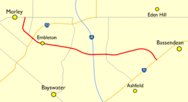 | |
| Map of Collier Road, highlighted in red, with surrounding suburbs and road network | |
| General information | |
| Type | Road |
| Length | 4.7 km (2.9 mi)[1] |
| Major junctions | |
| NW end | Walter Road |
| |
| SE end |
|
| Location(s) | |
| LGA(s) | City of Bayswater, Town of Bassendean |
| Major suburbs | Morley, Embleton, Bayswater, Bassendean |
Collier Road is a 4.7 kilometre main road in the inner north-eastern suburbs of Perth, Western Australia, linking Morley in the north-west, with Bassendean in the south-east. It services an industrial area in Bayswater and Bassendean, and connects to Tonkin Highway.
Route Description
Collier Road is a four-lane road for its entire length, with a speed limit of 60 km/h from Walter Road to Grey/Jackson Streets, and 70 km/h from Grey/Jackson Streets to Guildford Road.[2]
Collier Road starts at a traffic light controlled t-junction with Walter Road in Morley. From there, it travels southwards, past the Galleria Shopping Centre and other various commercial buildings on the west, and residential housing on the east, bending a little to the east after 0.4 kilometres (0.25 mi). After 0.2 kilometres (0.12 mi), Crimea Street meets up with Collier Road at an unsignalised t-junction. After another 0.2 kilometres (0.12 mi), Collier Road comes to a traffic light controlled intersection with Broun Avenue at the boundary of Morley and Embleton. From there, Collier Road is surrounded by residential houses in Embleton. After 0.2 kilometres (0.12 mi), the road bends a bit more, so now it is travelling eastwards.
After 1 kilometre (0.62 mi) of straight road, there is a traffic light controlled intersection on the boundary of Embleton and Bayswater with Beechboro Road South on the south, and Embleton Avenue on the north. From there, Collier Road is surrounded on both sides by industrial buildings. After 0.7 kilometres (0.43 mi), Collier Road comes to a Single Point Urban Interchange with Tonkin Highway, with Collier Road going over the top of Tonkin Highway, which is free flowing.
0.4 kilometres (0.25 mi) later, Collier Road comes to a traffic light controlled intersection on the boundary of Bayswater and Bassendean, as well as the City of Bayswater and the Town of Bassendean with Jackson Street on the south and Grey Street on the north. For 1.7 kilometres (1.1 mi), Collier Road bends north, and then south, mostly through an industrial area, but with a small bit of residential on the east, near the end. At the end, Collier Road crosses the Midland railway line before terminating just after at a t-junction with Guildford Road.
History
Collier Road used to connect through to Wellington Road on its north-western terminus, but during the 1980s, Collier Road was redirected to make room for the Galleria Shopping Centre. Remnants of the old alignment of Collier Road are still there, with a small portion of Collier Road, now named Old Collier Road used as an entrance to the Galleria Shopping Centre. Collier Road was also realigned in Bassendean. It used to travel straight towards Bassendean railway station, before traveling along the north side of the railway, but now it bends towards Guildford Road earlier.[3]
Between mid 2016 and early 2018,[4] as part of NorthLink WA, Collier Road was realigned between Wright Street and Grey / Jackson Street. A Single point urban interchange was built at the junction of Collier Road and Tonkin Highway, replacing the previous at-grade intersection.[5] Also, traffic lights were added to Collier Road's junctions with Wright Street and Grey / Jackson Street. The project was needed to make Tonkin Highway freeway standard and to replace the intersection of Collier Road and Tonkin Highway, as it was the third most congested intersection in Western Australia in 2016.[6][7][8]
Due to Collier Road being realigned, the roads around the area had to be renamed. The City of Bayswater city officers suggested the names Walkenden Road for the bypassed section of Collier Road west of Tonkin Highway, Greenaish Road east of Tonkin Highway, and a small portion of Spencer Street north of Collier Road to Seal Street, but the City of Bayswater knocked back those suggestions at a committee meeting on 20 June 2017. Local businesses on the bypassed section of Collier Road wanted it to keep its current name, and rename the new section of Collier Road, saying that they could lose lots of money, and that they will have to change lots of things, such as contracts and banking details.[9][10] On 14 August 2017, City of Bayswater councillors and staff, Landgate, NorthLink WA, and affected businesses met, and all agreed on keeping the name Collier Road for the existing section of road, and naming the new section of road something else. On 22 August 2017, the City of Bayswater council agreed to keep the name Collier Road for the existing section of road, with the new section to be named Collier Link, and the northern part of Spencer Street renamed Seal Street.[11][12]
Future
Both Main Roads Western Australia and the Public Transport Authority say that the Collier Road level crossing with the Midland railway line is going to be grade separated, however it is not a priority, because there are more congested level crossings in Perth. There are no plans of how the grade separation will happen, and the government has not allocated any money to it.[13][14]
Junction List
| LGA[15][16] | Location[2] | km | mi | Destinations | Notes |
|---|---|---|---|---|---|
| Bayswater | Morley | 0.0 | 0.0 | Walter Road – Bedford, Dianella, Inglewood | Collier Road north-eastern terminus; Traffic light controlled t-junction |
| 0.6 | 0.37 | Crimea Street – Noranda, Malaga | T-junction | ||
| Morley–Embleton boundary | 0.8 | 0.50 | Traffic light controlled intersection | ||
| Embleton–Bayswater boundary | 1.9 | 1.2 | Beechboro Road South south / Embleton Avenue north – Bayswater, Embleton, Morley | Traffic light controlled intersection | |
| Bayswater | 2.3 | 1.4 | Wright Street south / Collier Road north – Bayswater | South-eastbound traffic continues on Collier Link; North-westbound traffic continues on Collier Road; Traffic light controlled intersection | |
| 2.6 | 1.6 | Single-point urban interchange | |||
| Bayswater–Bassendean boundary | Bayswater–Bassendean boundary | 3.1 | 1.9 | Jackson Street south / Grey Street north | South-eastbound traffic continues on Collier Road; North-westbound traffic continues on Collier Link; Traffic light controlled intersection |
| Bassendean | Bassendean | 4.6 | 2.9 | Midland railway line | Level crossing |
| 4.7 | 2.9 | Collier Road south-eastern terminus; Traffic light controlled t-junction |
References
- ↑ "Google Maps". Google. Google. Retrieved 28 December 2017.
- 1 2 "Road Information Mapping System". Main Roads Western Australia. Retrieved 2 January 2018.
- ↑ "Metropolitan Region Scheme 1963" (PDF). Department of Planning. Retrieved 5 January 2018.
- ↑ "Timeline". Main Roads Western Australia. Retrieved 5 January 2018.
- ↑ "Southern Section Concept Plan" (PDF). Main Roads Western Australia. Retrieved 5 January 2018.
- ↑ Acott, Kent (28 November 2016). "Most choked intersection is too expensive to fix: Main Roads". Seven West Media. The West Australian. Retrieved 4 January 2018.
- ↑ Acott, Kent (28 November 2016). "Perth's most congested intersections". Seven West Media. Perth Now. Retrieved 4 January 2018.
- ↑ Johnston, Grieg (5 December 2016). "Perth's worst intersections: WA tipped to be nation's congestion leader". Community News. Southern Gazette. Retrieved 4 January 2018.
- ↑ Lim, Kristie (10 August 2017). "Road rage: Bayswater businesses fight to keep Collier Road address". Eastern Reporter. Community News. Retrieved 5 January 2018.
- ↑ "Business owners' fury over street name change". The West Australian. Seven West Media. Retrieved 5 January 2018.
- ↑ Lim, Kristie (24 August 2017). "City of Bayswater resolves issues around road name changes near Collier Rd". Eastern Reporter. Community News. Retrieved 5 January 2018.
- ↑ "Proposed naming of portions of Collier Rd, Spencer St and Wright St". Engage Bayswater. Retrieved 5 January 2018.
- ↑ "ALP puts spotlight on dangerous level crossings". Community News. Eastern Reporter. 6 October 2015. Retrieved 4 January 2018.
- ↑ "Ashfield Precinct Plan" (PDF). Department of Planning. Retrieved 4 January 2018.
- ↑ "Ward Information". City of Bayswater. Retrieved 2 January 2018.
- ↑ "Intramaps". Retrieved 2 January 2018.