Severn, Ontario
| Severn | |
|---|---|
| Township (lower-tier) | |
| Township of Severn | |
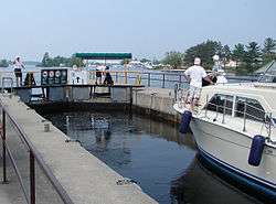 The Trent-Severn Waterway in Port Severn. | |
 Severn Location of Severn in Ontario | |
| Coordinates: 44°45′N 79°31′W / 44.750°N 79.517°WCoordinates: 44°45′N 79°31′W / 44.750°N 79.517°W | |
| Country |
|
| Province |
|
| County | Simcoe |
| Incorporated | January 1, 1994 |
| Government | |
| • Mayor | Mike Burkett |
| • MPs | Bruce Stanton |
| • MPPs | Patrick Brown |
| Area[1] | |
| • Land | 549.75 km2 (212.26 sq mi) |
| Population (2016)[1] | |
| • Total | 13,477 |
| • Density | 24.5/km2 (63/sq mi) |
| Time zone | UTC-5 (Eastern (EST)) |
| • Summer (DST) | UTC-4 (EDT) |
| FSA | L0K |
| Area code(s) | 705 |
| Website | www.townshipofsevern.com |
Severn is a township in south-central Ontario, Canada, located between Lake Couchiching, and the Severn River (both are part of the Trent–Severn Waterway) in Simcoe County.
Communities
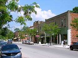
The township comprises the communities of Amigo Beach, Ardtrea, Buckskin, Buena Vista Park, Burnside, Carlyon, Coldwater, Cumberland Beach, Fesserton, Hamlet, Hampshire Mills, Happyland, Hawkins Corner, Hydro Glen, Lovering, Maple Valley, Marchmont, Medonte, Menoke Beach, Mordolphin, Mount Stephen, Port Severn, Port Stanton, Scarlet Park, Severn Falls, Swift Rapids, Uhthoff, the Uhthoff Hunt Camp, Wilson Point and Washago.
History
Chief John Aisance and his band of Chippewas (also known as Ojibwa) settled along the Coldwater River in 1830, calling the place Gissinausebing, which means "cold water." They built a grist mill on the site in 1833, which the Native people owned until 1849. In 1835 a post office was established, and the community was called Coldwater.
Coldwater was opened to European settlement in 1836, and was incorporated as a village in 1908. Three weekly newspapers have been published in the community: the Coldwater Planet (1896 to 1928), the Coldwater News (1895 to 1956); and the Coldwater Canadian in 1956.
At the mouth of the Severn River, another community sprang up. The residents called it Severn Mills after a sawmill was built there around 1850. Lumber from this area was sent out on ships. The village was renamed to Port Severn in 1868. In 1875, the Georgian Bay Lumber Co. was formed, soon to become the major lumber producer in the Severn River watershed.
The settlement expanded rapidly over the next 20 years. In 1896, the mill was struck by lightning and burned to the ground. Since the timber supply in the area had been greatly reduced, the mill was not rebuilt and the population of the village began to decline. With the completion of the Trent–Severn Waterway in this area in 1915, economic activity shifted from lumber to tourism.
The current township of Severn was founded on January 1, 1994, as part of the restructuring of Simcoe County, by amalgamating the village of Coldwater with the townships of Matchedash and Orillia, plus portions of the townships of Medonte and Tay.
Demographics
| Canada census – Severn, Ontario community profile | |||
|---|---|---|---|
| 2011 | 2006 | ||
| Population: | 12,377 (2.9% from 2006) | 12,030 (8.0% from 2001) | |
| Land area: | 549.90 km2 (212.32 sq mi) | 534.78 km2 (206.48 sq mi) | |
| Population density: | 22.5/km2 (58/sq mi) | 22.5/km2 (58/sq mi) | |
| Median age: | 44.3 (M: 44.5, F: 44.1) | ||
| Total private dwellings: | 6643 | 6491 | |
| Median household income: | $57,638 | ||
| References: 2011[2] 2006[3] earlier[4] | |||
Notable people
- Glenn Howard - Curler for Team Ontario, 2007 Brier Winner, and 2007 World Curling Champion for Team Canada
In film
- The television series, Paradise Falls, was shot in the township between 2001-2008. Port Stanton, Severn Falls and various locations around Sparrow Lake were used.
See also
References
- 1 2 "Severn census profile". 2011 Census of Population. Statistics Canada. Retrieved 2012-03-06.
- ↑ "2011 Community Profiles". Canada 2011 Census. Statistics Canada. July 5, 2013. Retrieved 2012-03-06.
- ↑ "2006 Community Profiles". Canada 2006 Census. Statistics Canada. March 30, 2011. Retrieved 2012-03-06.
- ↑ "2001 Community Profiles". Canada 2001 Census. Statistics Canada. February 17, 2012.
External links
| Wikivoyage has a travel guide for Washago. |
Places adjacent to Severn, Ontario | |
|---|---|