Code River
| Codé River (ꦏꦭꦶꦕꦺꦴꦝꦺ Kali Codhe, Kali Code) | |
| Kali Tjode, Sungai Code, Sungai Boyong | |
| River | |
| Country | |
|---|---|
| State | Yogyakarta |
| Coordinates | 7°53′38″S 110°23′12″E / 7.89389°S 110.38667°E |
| Source | Mount Merapi |
| Mouth | Opak River |
| - location | Giwangan, Umbulharjo, Yogyakarta |
| - elevation | 67 m (220 ft) |
| Timezone | IWST (UTC+7) |
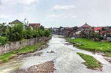

Code (Indonesian pronunciation: [tʃode]; Indonesian: Kali Code) is the name of a river that flows through the city of Yogyakarta on the island of Java, Indonesia.[1][2][3] Pollution is a problem along the river.[4] Sayidan Bridge crosses the river.[4]
Geography
The river flows in the southern central area of Java with predominantly tropical savanna climate (designated as As in the Köppen-Geiger climate classification).[5] The annual average temperature in the area is 24°C. The warmest month is September, when the average temperature is around 27°C, and the coldest is April, at 20°C.[6] The average annual rainfall is 2802 mm. The wettest month is January, with an average of 538 mm rainfall, and the driest is September, with 8 mm rainfall.[7]
Settlements
Settlements by poor people have been created beside the river over time. [8][9] Also loss of housing close to the river has occurred during severe eruptions from Mount Merapi. [10]
References
- ↑ Down by the riverside - Kali Code by Tessa Toumbourou Inside Indonesia 95: Jan-Mar 2009
- ↑ The Neighborhood Upgrading and Shelter Sector Project in Indonesia. Asian Development Bank. 2012. p. 36. ISBN 978-92-9092-721-1. Retrieved 2015-10-07.
- ↑ Kali Code at Geonames.org (cc-by); Last updated 2012-01-17; Database dump downloaded 2015-11-27
- 1 2 "River Pollution in Yogyakarta Worsens". En.tempo.co. 2014-03-13. Retrieved 2015-10-07.
- ↑ Peel, M C; Finlayson, B L; McMahon, T A (2007). "Updated world map of the Köppen-Geiger climate classification". Hydrology and Earth System Sciences. 11. doi:10.5194/hess-11-1633-2007.
- ↑ "NASA Earth Observations Data Set Index". NASA. 30 January 2016.
- ↑ "NASA Earth Observations: Rainfall (1 month - TRMM)". NASA/Tropical Rainfall Monitoring Mission. 30 January 2016.
- ↑ Kutanegara, Pande Made (2014), Manusia, lingkungan, dan sungai : transformasi sosial kehidupan masyarakat sempalan Sungai Code, Yogyakarta Penerbit Ombak, ISBN 978-602-258-173-4
- ↑ Guiness, Patrick (April 1983), "The gelandangan of Yogyakarta. -illegally settled urban fringe dwellers-", Bulletin of Indonesian Economic Studies, 19 (Apr 1983): 68–82, ISSN 0007-4918
- ↑ "Indonesia Builds 500 Temporary Shelters for Mt Merapi Victims Along Code River", Indonesia Government News, Athena Information Solutions Pvt. Ltd, 2010-12-13, retrieved 4 August 2017