Cochrane Airfield
| Cochrane Airport | |||||||||||
|---|---|---|---|---|---|---|---|---|---|---|---|
 | |||||||||||
| Summary | |||||||||||
| Airport type | Public | ||||||||||
| Serves | Cochrane, Chile | ||||||||||
| Elevation AMSL | 643 ft / 196 m | ||||||||||
| Coordinates | 47°14′36″S 72°35′10″W / 47.24333°S 72.58611°WCoordinates: 47°14′36″S 72°35′10″W / 47.24333°S 72.58611°W | ||||||||||
| Map | |||||||||||
 SCHR Location in Chile | |||||||||||
| Runways | |||||||||||
| |||||||||||
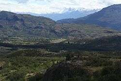
Cochrane Airport Spanish: Aeródromo Cochrane, (IATA: LGR, ICAO: SCHR) is an airport serving Cochrane, a town in the Aysén Region of Chile. The airport is just northwest of the town, at the foot of Cerro Tamanguito (sv).
The region around Cochrane is mountainous. There are ravines off either end of the runway, with rising terrain beyond.
See also


- Transport in Chile
- List of airports in Chile
References
- ↑ SCHR at IFIS Chile. Retrieved 2017-01-08.
- ↑ Airport record for Cochrane Airport at Landings.com. Retrieved 2013-09-06
- ↑ Google (2013-09-06). "location of Cochrane Airport" (Map). Google Maps. Google. Retrieved 2013-09-06.
- ↑ Airport information for Cochrane Airport at Great Circle Mapper.
External links
- OpenStreetMap - Cochrane
- OurAirports - Cochrane Airport
- SkyVector - Cochrane
- FallingRain - Cochrane Airport
- Accident history for Cochrane Airport at Aviation Safety Network
- Current weather for Cochrane Airport at NOAA/NWS
This article is issued from
Wikipedia.
The text is licensed under Creative Commons - Attribution - Sharealike.
Additional terms may apply for the media files.