Cobden/Bruce McPhail Memorial Airport
| Cobden/Bruce McPhail Memorial Airport | |||||||||||||||
|---|---|---|---|---|---|---|---|---|---|---|---|---|---|---|---|
 | |||||||||||||||
| Summary | |||||||||||||||
| Airport type | Private | ||||||||||||||
| Operator | Champlain Flying Club | ||||||||||||||
| Location | Cobden, Ontario | ||||||||||||||
| Time zone | EST (UTC−05:00) | ||||||||||||||
| • Summer (DST) | EDT (UTC−04:00) | ||||||||||||||
| Elevation AMSL | 500 ft / 152 m | ||||||||||||||
| Coordinates | 45°35′43″N 076°50′03″W / 45.59528°N 76.83417°WCoordinates: 45°35′43″N 076°50′03″W / 45.59528°N 76.83417°W | ||||||||||||||
| Map | |||||||||||||||
 CPF4 Location in Ontario | |||||||||||||||
| Runways | |||||||||||||||
| |||||||||||||||
|
Source: Canada Flight Supplement[1] | |||||||||||||||
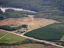
Cobden/Bruce McPhail Memorial Airport, (TC LID: CPF4), is located 2.4 nautical miles (4.4 km; 2.8 mi) southeast of Cobden, Ontario, Canada.
References
- ↑ Canada Flight Supplement. Effective 0901Z 19 July 2018 to 0901Z 13 September 2018.
| By name | |
|---|---|
| By location indicator | |
| By province/territory | |
| By area | |
| National Airports System | |
| Related | |
| |
This article is issued from
Wikipedia.
The text is licensed under Creative Commons - Attribution - Sharealike.
Additional terms may apply for the media files.