Cobb Mountain
| Cobb Mountain | |
|---|---|
 | |
| Highest point | |
| Elevation | 4723+ ft (1440+ m) NAVD 88[1] |
| Prominence | 3,160 ft (963 m) [1] |
| Listing | California county high point |
| Coordinates | 38°48′27″N 122°44′26″W / 38.8074045°N 122.740546°WCoordinates: 38°48′27″N 122°44′26″W / 38.8074045°N 122.740546°W [2] |
| Geography | |
| Location | California county high points 42nd |
| Parent range | Mayacamas Mountains |
| Topo map | USGS Whispering Pines |
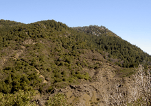
Cobb Mountain is the tallest mountain in the Mayacamas Mountains of California. Its 4720+ feet, (1439+ m) main summit[1] is located in Lake County, west of the town of Cobb. Like nearby Mount Saint Helena, Cobb Mountain is tall enough to receive winter snowfall.[3] The mountain also has a sub-peak named Cobb Mountain – Southwest Peak with an elevation of about 4483+ feet, (1367+ m) NAVD 88;[4] Southwest Peak lies on the Sonoma-Lake county line and is the highest point in Sonoma County. Nearby tall peaks like Mount Saint Helena and Snow Mountain can be seen from this summit.[5]
The east end of Cobb Mountain drains into the headwaters of Putah Creek, then into the Sacramento River, the San Francisco Bay, and the Pacific Ocean. The south slopes of Cobb Mountain drain into Anderson Creek, and thence into Putah Creek. The southwest slopes of Cobb Mountain drain into Cobb Creek, thence into Big Sulphur Creek, the Russian River, and into the Pacific. The northwest slopes of Cobb Mountain drain into Alder Creek, thence into Kelsey Creek, Clear Lake, Cache Creek, and the Sacramento River. The northeast slopes of Cobb Mountain drain into Kelsey Creek.[6]
Much of Cobb Mountain lies within The Geysers Geothermal Field, and several geothermal plants are located on the mountain. Other areas on the mountain are owned by Cobb Mountain Spring Water (now sold as Mayacamas Mountain Spring Water) or are privately held timberlands. Because much of Cobb Mountain is privately owned, it is largely not accessible to the general public.
History
The mountain is named after John Cobb, the first pioneer to settle in the area. Cobb was born in Henry County, Kentucky on May 19, 1814. In 1853 he arrived in California and homesteaded in Cobb Valley and went on to become the county assessor and the road overseer for the Clearlake District in 1855. He built a combined saw and gristmill in 1859, which was later destroyed by fire. He sold his interests and moved to Napa County around 1860.[7]
The Cobb Mountain area was devastated in 2015 by the Valley Fire, including much of the town of Cobb, as well as several geothermal facilities.
References
- 1 2 3 "Cobb Mountain, California". Peakbagger.com. Retrieved 2009-07-05.
- ↑ "Cobb Mountain". Geographic Names Information System. United States Geological Survey. Retrieved 2009-07-05.
- ↑ "Subsection M261Be Konocti Flows". USDA, Forest Service. Archived from the original on 2011-09-22. Retrieved 2007-10-07.
- ↑ "Cobb Mountain-Southwest Peak, California". Peakbagger.com. Retrieved 2009-07-05.
- ↑ Height and visual lines-of-sight are based on Google Earth images.
- ↑ Whispering Pines quadrangle, California (Map). 1:24000. 7.5 Minute Topographic. USGS. Retrieved 2010-01-04.
- ↑ Mauldin, Henry (1995). Mountains & Pioneers of Lake County. Kelseyville, CA: Earthen Vessels Productions, Inc. p. 10. ISBN 978-1-887400-22-0.
External links
- "Cobb Mountain". SummitPost.org. Retrieved 2011-05-07.