Coal Aston Airfield
| Coal Aston Airfield | |||||||||||
|---|---|---|---|---|---|---|---|---|---|---|---|
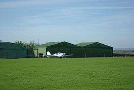 Hangars at Coal Aston Airfield | |||||||||||
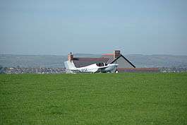 Turning onto runway 11 at Coal Aston Airfield. Farmhouse can be found by following the farm track | |||||||||||
| Summary | |||||||||||
| Airport type | Private | ||||||||||
| Owner/Operator | Richard Vallé / Steven Vallé | ||||||||||
| Elevation AMSL | 720 ft / 219 m | ||||||||||
| Coordinates | 53°18′17″N 001°25′50″W / 53.30472°N 1.43056°WCoordinates: 53°18′17″N 001°25′50″W / 53.30472°N 1.43056°W | ||||||||||
| Map | |||||||||||
 Coal Aston Location in Derbyshire | |||||||||||
| Runways | |||||||||||
| |||||||||||
Coal Aston Airfield (ICAO: EGCA), also known as Dronfield Airfield, Apperknowle Airfield and Summerley Airfield, is a general aviation airfield located in the village of Summerley, near Apperknowle, Derbyshire, 5 NM (9.3 km; 5.8 mi) south-east of central Sheffield, England.
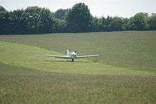
The unlicensed airfield consists of a single 600-metre-long grass runway; the runway is not entirely flat, with a dip in the middle and a hump at the eastern end. The runway is located atop a ridge of high ground east of and above the town of Dronfield, close to the villages of Summerley, Apperknowle and Coal Aston. The airfield is operated from a nearby farmhouse and prior permission is required for landing. The airfield took over from the legacy of RAF Coal Aston, which was situated on what is now the Jordanthorpe estate in Sheffield 1.5 NM (2.8 km; 1.7 mi) to the north-west. The original RAF Coal Aston closed sometime in the 1920s.
The older hangar at Coal Aston is a Blister-type hangar, made famous during the interwar years. It was erected by United Steel Companies Limited, later to become British Steel, in 1961. The runway was at that time at its maximum length of around 800 metres; it has since been reduced to 610 metres in 2015. A second hangar was later erected in the 1980s, and this sits alongside the original. In 1995, the airstrip achieved permanent permission for use as an airfield; it is now one of the last remaining traditional grass airfields in Derbyshire. Since the 1990s, a number of low-environmental impact aircraft have been continuously based at the airfield.
A public footpath follows the northern and western perimeter of the airfield. There is no public right of way across the site. Between aircraft movements, the grass runway and adjacent fields are grazed by cattle. Overnight parking of aircraft is possible and hangarage is available in one of the two hangars on site. A range of aircraft types may be accepted to the airfield at the owners' discretion, including non-radio traffic.
On 28 May 2017, a light aircraft crashed on Summerley Road, several hundred metres short of the runway in the nearby village of Summerley, while on final approach to Coal Aston Airfield. The pilot, who was the sole occupant of the aircraft, was killed in the accident.[1]
References
3. Pooleys Flight Guide June 2016
4. Flight magazine April 1961