Clifton, Nottingham
| Clifton | |
|---|---|
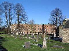 Clifton Hall | |
 Clifton Clifton shown within Nottinghamshire | |
| Population | 26,835 Clifton North and South Wards 2011 |
| OS grid reference | SK 55315 34309 |
| Unitary authority | |
| Ceremonial county | |
| Region | |
| Country | England |
| Sovereign state | United Kingdom |
| Post town | NOTTINGHAM |
| Postcode district | NG11 |
| Dialling code | 0115 (921 / 940 / 945 /984) |
| Police | Nottinghamshire |
| Fire | Nottinghamshire |
| Ambulance | East Midlands |
| EU Parliament | East Midlands |
| UK Parliament | |
Clifton is a former village and historic manor, now situated within the suburbs of the city of Nottingham, Nottinghamshire, England, United Kingdom.
Clifton has 2 wards in the City of Nottingham (North and South) with a total population taken at the 2011 Census of 26,835.[1][2] The location also encompasses Clifton Grove and Clifton Village, a picturesque residential area set alongside the River Trent.
The Manor of Clifton was for many centuries the seat of the de Clifton (later Clifton) family, branches of which were in the 17th century created Baron Clifton of Leighton Bromswold (1608) and Clifton baronets (1611). It is now the site of a council estate. The village is also notable for many old buildings including Clifton Hall, former seat of the Clifton family, and St. Mary's Church.
History
The manor of Clifton was recorded in the Domesday Book of 1086 as having a church and a mill. The value of the manor had decreased since the Norman Conquest of 1066 from £16 to £9.[3] For 700 years the Clifton family of Clifton owned the manor, of which their manor house was Clifton Hall. The papers of the Clifton family and their lands are held at Manuscripts and Special Collections, The University of Nottingham.
Prior to Clifton being subsumed into the city, the area was previously in a parish called Clifton with Glapton until 1952,[4] Glapton being a small scatterring of houses and farms prior to when the estate was built, and was in the area approximately where present day Glapton Lane is, there still being some older houses that predate the estate along the lane.[5]
Modern Clifton
The council estate has a number of shop-clusters and relatively good transport links (by tram and bus) with the city (~20 minutes) and surrounding areas. The village is on the A453 road which is the main connection between Nottingham and the M1 motorway south. The section of the A453 from Kegworth to the roundabout next to the Crusader pub has been upgraded to dual carriageway, this project was completed by 2016.[6]
Clifton Council Estate
The Clifton Council Estate is a sprawling conurbation, which was first considered for residential construction in 1952 by Act of Parliament, and at one time the largest council estate in Europe. The majority of the houses are made of "no fines" concrete (concrete which only has large aggregate included). This leaves air filled voids which add thermal insulation. Since the 1980s most of the houses have passed from council to private ownership. Clifton (like some of Nottingham's other estates) has benefited in recent years from redevelopment and regeneration work initiated by the city council. The most recent is a walled community for the elderly opposite the junction of Gotham Road and Farnborough Road called Lark Hill Village which opened to residents in August 2009. There are currently plans for an extension of Clifton to the south, to be known as Fairham Pastures[7]
Governance
Local government matters are administered by Nottingham City Council, a unitary authority. Clifton is split into two wards: Clifton South includes Clifton Village, Barton Green, Nobel Road Estate and Clifton Estate south of Glapton Lane and south from Lanthwaite Road and Bainton Grove. It is represented by Cllrs Christopher (Chris) Gibson, Corall Jenkins and Steve Young (all Labour). Clifton North includes the rest of Clifton (including Clifton Grove), plus the Wilford area. It is represented on Nottingham City Council by councillor(s) Andrew Rule and Roger Steel (both Conservative) as well as Josh Cook (Labour).
Parliamentary, Clifton falls within the Nottingham South constituency, with Lilian Greenwood the current Member of Parliament.
Education
Primary schools include Milford, Glapton, Whitegate, Highbank, Dovecote (an amalgamation of Greencroft, Brooksby and Brinkhill) and Blessed Robert Widmerpool. The Farnborough Academy on Farnborough Road is the mainstream secondary school for the area, while Nethergate School on Swansdown Drive is an all-through special school. The Nottingham Trent University has one of its campuses on Clifton Lane (A453). On Farnborough Road is also one of the Central College Nottingham campuses.
On what is now wasteland, accessible from Brooksby Lane or Silverdale Walk, remain the foundations of the original Brooksby School, which was burnt down in the early 1980s. Brooksby school was then moved to the location now known as Dovecote School taking a building originally a part of Greencroft School.
Sport
Clifton has six football teams: Clifton All Whites, Clifton Aces, Clifton Blacks, Clifton Wanderers, Clifton FC and FC Olympico.
Most famous players are Viv Anderson, Jermaine Jenas, Darren Huckerby and somehow Scott Hall??
Transport
Tram service
Clifton is the terminus of line 2 of the Nottingham Express Transit tramway, which opened in August 2015. The line runs from a terminus at a Park & Ride site just to the west of Clifton, through Clifton, Wilford, and Nottingham City Centre, before continuing to Phoenix Park in the north of the city. Trams run at frequencies that vary between 4 and 8 trams per hour, depending on the day and time of day. The following stops are in, or near to, Clifton:[8]
Bus Services
| Bus operator | Line | Destination(s) | Notes |
|---|---|---|---|
| Nottingham City Transport | 1 | Nottingham → Railway Station → Trent Bridge → Wilford Lane → NTU Clifton Campus → Clifton → Gotham → East Leake → Loughborough | [9] |
| 1A | Nottingham → Railway Station → Trent Bridge → Wilford Lane → NTU Clifton Campus → Clifton | [10] | |
| 1B | Nottingham → Railway Station → Trent Bridge → Wilford Lane → NTU Clifton Campus → Clifton | [11] | |
| 3 | Nottingham → Railway Station → Wilford Lane → Ruddington → Clifton (Farnborough Road, Southchurch Drive, Hartness Road) | [12] | |
| 4 | NTU City Campus → Nottingham → Railway Station → Trent Bridge → Wilford Lane → NTU Clifton Campus | Line serves during NTU term only.[13] | |
| 48 | Nottingham → Railway Station → Meadows → Electric Avenue → Clifton Bridge → Clifton (Southchurch Drive, Nobel Road) | [14] | |
| 48X | Nottingham → Railway Station → Meadows → Queen's Drive → Clifton Bridge → Clifton (Southchurch Drive, Nobel Road) | [15] | |
| 53 | Arnold → Daybrook → City Hospital → Basford → Western Boulevard → Jubilee Campus → QMC → Showcase Cinemas → Clifton | [16] | |
| 53B | Daybrook → City Hospital → Basford → Western Boulevard → Jubilee Campus → QMC → Showcase Cinemas → Clifton | [17] | |
| N4 | NTU City Campus → Nottingham → Railway Station → Trent Bridge → Wilford Lane → NTU Clifton Campus | Line serves at night and during NTU term only.[18] | |
| N48 | Nottingham → Railway Station → Meadows → Clifton → Ruddington | Line serves at night only.[19] | |
| Trentbarton | Skylink Express | Nottingham → Clifton → East Midlands Airport | [20] |
| Nottingham Community Transport | L1 | Nottingham → Railway Station → Victoria Embankment → Wilford Village → Clifton → The Downs → Silverdale | [21] |
| L22 | Gamston → West Bridgford → Ruddington → Clifton | [22] | |
| L23 | Gamston → Clifton → Ruddington → West Bridgford | [23] | |
| L64 | Nottingham → QMC → Fabis Drive → Clifton | [24] | |
| Silverdale Tours | S1 | Clifton → Wilford Green → Asda West Bridgford → West Bridgford → Gamston Morrisons | [25] |
| University Hopperbus | 901 | Nottingham (Weekends) → University Park → Showcase Cinemas → Clifton Lane → Sutton Bonington | [26] |
Notable people
- Jake Bugg, musician
- Karl Collins, actor
- Samantha Morton, actress
- Jayne Torvill, ice skater, Olympic gold medalist
- Viv Anderson, footballer
- Darren Huckerby, footballer
- Jermaine Jenas, footballer, pundit
- Alan Higgott, football manager extraordinaire
References
- Notes
- ↑ "City of Nottingham. Clifton South ward population 2011". Neighbourhood Statistics. Office for National Statistics. Retrieved 18 April 2016.
- ↑ "City of Nottingham, Clifton North ward population 2011". Neighbourhood Statistics. Office for National Statistics. Retrieved 18 April 2016.
- ↑ Williams (ed.) (2003), pp. 770–771.
- ↑ "Clifton With Glapton | Census tables with data for the Parish-level Unit". www.visionofbritain.org.uk. Retrieved 2017-04-25.
- ↑ "Genuki: White's Directory of Nottinghamshire, 1853, Nottinghamshire". www.genuki.org.uk. Retrieved 2017-04-25.
...including the ancient hamlet of Glapton, that forms part of the village, and is now lost in the general name of Clifton, its own name being seldom used except in the parish documents, in which the parish is sometimes called " Clifton-cum-Glapton"
- ↑ "A453 Widening (M1 Junction 24 to A52 Nottingham)". Highways Agency. Retrieved 28 November 2008.
- ↑ http://fairham-pastures.com/index.php
- ↑ "Extending your Tram Service" (PDF). Nottingham Express Transit. Archived from the original (PDF) on 7 August 2015. Retrieved 5 August 2015.
- ↑
- ↑
- ↑
- ↑
- ↑
- ↑
- ↑
- ↑
- ↑
- ↑
- ↑
- ↑
- ↑
- ↑
- ↑
- ↑
- ↑
- ↑
- Bibliography
- History of Clifton
- Williams, Ann, ed. (2003). Domesday Book: A Complete Translation. Penguin Classics. ISBN 0-14-143994-7.
External links
| Wikimedia Commons has media related to Clifton, Nottinghamshire. |
- Clifton Village website
- Papers of the Clifton family, held at Manuscripts and Special Collections at The University of Nottingham
- Pictures of Clifton Village from Nottingham21
| About Nottingham | |
|---|---|
| Areas of Nottingham | |
| |
| Unitary authorities | |
|---|---|
| Boroughs or districts | |
| Major settlements | |
| Topics | |