Clevedon, New Zealand
| Clevedon | |
|---|---|
| Basic information | |
| Local authority | Auckland City |
| Electoral ward | Franklin |
| Date established | 1866 |
| Surrounds | |
| North | Maraetai |
| Northeast | Kawakawa Bay |
| East | (Hunua Ranges) |
| Southeast | (Hunua Ranges) |
| South | (Hunua Ranges) |
| Southwest | Papakura |
| West | Brookby |
| Northwest | Whitford |
| Clevedon | |
|---|---|
| Town | |
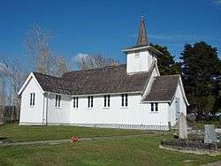 All Souls Church | |
 Clevedon | |
| Coordinates: 37°0′S 175°3′E / 37.000°S 175.050°E | |
| Country |
|
| Region | Auckland Region |
| Territorial authority | Auckland Council |
| Ward | Franklin |
| Population (2006) | |
| • Total | 2,508 |
| Website | Clevedon town website |
Clevedon, earlier known as Wairoa South, is a rural town in Auckland, New Zealand, located in the Franklin ward, one of the thirteen administrative divisions of Auckland city. The town is governed by the Auckland Council.
Description
The town and surrounding rural area has a population of 2,508 (2006 census),[1] and is the centre of an administrative ward of Manukau which takes in much of the largely rural area to the east of the urban heart of the city.
Clevedon is located on the Wairoa River five kilometres from its estuary and outflow into the Tamaki Strait, an arm of the Hauraki Gulf. It is 14 kilometres from the centre of the suburb of Manukau, which lies to the northwest. To the south of Clevedon rise the rugged hills of the Hunua Ranges. Several popular beaches are located on the coast close to Clevedon, including Duder's Beach and Kawakawa Bay. Between these two beaches lies the Duder Regional Park.
Clevedon was named for Clevedon, England, in 1866. It was previously known as Te Wairoa (Māori: 'the Long River'). Te Wairoa and surrounding area is traditionally home of the Ngāi Tai or Ngāi Tai ki Tāmaki people, who are descendants of the Tainui waka. Ngāi Tai traversed their tribal domain, including the inner islands of the Hauraki Gulf, in a seasonal cycle of harvesting, gathering and fishing. In Te Wairoa River valley Ngā Tai maintained kainga at; Otau and Tuawa near present-day Clevedon, at Tararua near the mouth of the Rautawhiti Stream, and at Takatekauere, Te Totara, Te Ruato and Pehuwai on the western side of the River. In the vicinity of the Whakakaiwhara Peninsula there were settlements at Te Oue, Mawherawhera, Te Kuiti and Umupuia
There were formerly many schools located in Clevedon (the Wairoa district) but only one remains, Clevedon School.
All Souls Church is registered by Heritage New Zealand as a Category II structure, with registration number 682.[2]
The Hon Phil Goff, the current Mayor of Auckland and former Labour Party Leader and Foreign and Defence Minister, is a long term resident of Clevedon.
See also
References
- ↑ Quickstats about Clevedon
- ↑ "All Soul's Church (Anglican)". Register of Historic Places. Heritage New Zealand. Retrieved 7 July 2012.
- Reed, A. W. (2002). The Reed Dictionary of New Zealand Place Names. Auckland: Reed Books. ISBN 0-7900-0761-4. .
External links
| Wikimedia Commons has media related to Clevedon, New Zealand. |
Coordinates: 36°59′27″S 175°02′16″E / 36.990813°S 175.037774°E