Civic Center station (Metrorail)
| |||||||||||||||
|---|---|---|---|---|---|---|---|---|---|---|---|---|---|---|---|
| Metrorail metro station | |||||||||||||||
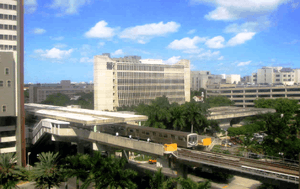 View from the UM/Jackson medical complex and Metrorail train entering the station | |||||||||||||||
| Location |
1501 NW 12th Avenue Miami, Florida | ||||||||||||||
| Coordinates | 25°47′23″N 80°12′54″W / 25.78972°N 80.21500°WCoordinates: 25°47′23″N 80°12′54″W / 25.78972°N 80.21500°W | ||||||||||||||
| Owned by | Miami-Dade County | ||||||||||||||
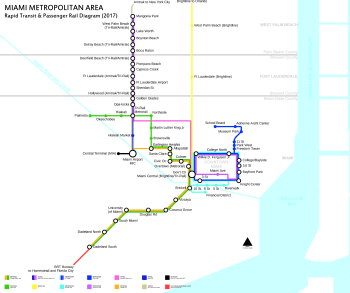
| Line(s) | |||||||||||||||
| Platforms | 2 side platforms | ||||||||||||||
| Tracks | 2 | ||||||||||||||
| Connections |
| ||||||||||||||
| Construction | |||||||||||||||
| Disabled access | Yes | ||||||||||||||
| Other information | |||||||||||||||
| Station code | CVC | ||||||||||||||
| History | |||||||||||||||
| Opened | December 17, 1984 | ||||||||||||||
| Traffic | |||||||||||||||
| Passengers (2011) |
1.7 million[1] | ||||||||||||||
| Services | |||||||||||||||
| |||||||||||||||
Civic Center station is a station on the Metrorail rapid transit system in Miami, Florida's Health District, which is also known as Civic Center. The station is located at the intersection of Northwest 12th Avenue (State Road 933) and 15th Street, opening to service December 17, 1984. Civic Center provides a convenient connection for University of Miami medical students by connecting the hospital area to the main campus at University station.
Station layout
| P Platform level |
Southbound | ← Green Line, Orange Line toward Dadeland South (Culmer) |
| Island platform, doors will open on the left | ||
| Northbound | Green Line toward Palmetto (Santa Clara) → Orange Line toward Miami Airport (Santa Clara) → | |
| G | Street level | Exit/entrance and buses |
Places of interest
- Jackson Memorial Hospital
- University of Miami Miller School of Medicine
- Bascom Palmer Eye Institute
- Veterans Hospital
- Marlins Park (1 mile walk south)
- Miami-Dade County Jail
- Miami-Dade Justice Building/Courts
- Florida State Building
- Cedars Medical Center
- Miami-Dade County Health Department
- University of Miami Hospitals and Clinics
References
- ↑ "(untitled)". Miami-Dade County.
External links

- MDT – Metrorail Stations
- entrance from Google Maps Street View
This article is issued from
Wikipedia.
The text is licensed under Creative Commons - Attribution - Sharealike.
Additional terms may apply for the media files.