Cimarron, Colorado
| Cimarron, Colorado | |
|---|---|
| Unincorporated community | |
 In 1883 | |
 Cimarron, Colorado Location within the state of Colorado | |
| Coordinates: 38°26′30″N 107°33′22″W / 38.44167°N 107.55611°WCoordinates: 38°26′30″N 107°33′22″W / 38.44167°N 107.55611°W | |
| Country |
|
| State |
|
| County | Montrose County |
| Elevation[1] | 2,102 m (6,896 ft) |
| Time zone | UTC-7 (MST) |
| • Summer (DST) | UTC-6 (MDT) |
| ZIP Code | 81220[2] |
Cimarron is an unincorporated community and U.S. Post Office in Montrose County, Colorado, United States. The Cimarron Post Office has the ZIP Code 81220.[2]
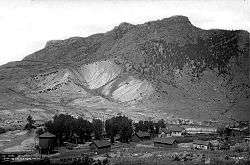
Cimarron is a small unincorporated community on the Cimarron River, just south of the Black Canyon of the Gunnison, and just outside Curecanti National Recreation Area. The D & RG Narrow Gauge Trestle crosses the Cimarron River gorge just northeast of town, and is on the National Register of Historic Places (#76000172).
Geography
Cimarron is located at 38°26′30″N 107°33′22″W / 38.44167°N 107.55611°W (38.441758,-107.555981).
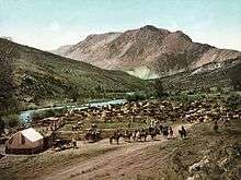
Round-up in a ranch just south of the town, 1898.
See also
References
- ↑ "US Board on Geographic Names". United States Geological Survey. 2007-10-25. Retrieved 2008-01-31.
- 1 2 "ZIP Code Lookup". United States Postal Service. December 15, 2006. Archived from the original (JavaScript/HTML) on September 3, 2007. Retrieved December 15, 2006.
Municipalities and communities of Montrose County, Colorado, United States | ||
|---|---|---|
| City | 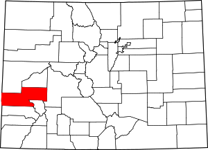 | |
| Towns | ||
| CDP | ||
| Unincorporated communities | ||
| Ghost town | ||
This article is issued from
Wikipedia.
The text is licensed under Creative Commons - Attribution - Sharealike.
Additional terms may apply for the media files.