Ciaotou Sugar Refinery MRT station
Ciaotou Sugar Refinery 橋頭糖廠 | |||||||||||
|---|---|---|---|---|---|---|---|---|---|---|---|
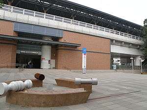 Ciaotou Sugar Refinery station exit 2 | |||||||||||
| Location |
Qiaotou, Kaohsiung Taiwan | ||||||||||
| Operated by | |||||||||||
| Line(s) |
| ||||||||||
| Platforms | One Island platform | ||||||||||
| Construction | |||||||||||
| Structure type | Elevated | ||||||||||
| History | |||||||||||
| Opened | 2008-03-09 | ||||||||||
| Traffic | |||||||||||
| Passengers | 1,359 daily (Jan. 2011)[1] | ||||||||||
| Services | |||||||||||
|
| |||||||||||
| Ciaotou Sugar Refinery MRT station | |||||||||||||
| Traditional Chinese | 橋頭糖廠站 | ||||||||||||
|---|---|---|---|---|---|---|---|---|---|---|---|---|---|
| Simplified Chinese | 桥头糖厂站 | ||||||||||||
| |||||||||||||
Ciaotou Sugar Refinery is a station on the Red line of Kaohsiung MRT in Qiaotou District, Kaohsiung City, Taiwan.
Station Overview
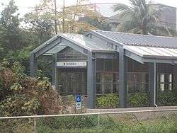
Closed exit 1 of the Ciaotou Sugar Refinery station
The station is a three-level, elevated station with one island platforms and three exits.[2] It is 167 meters long and is located near the Taiwan Sugar dormitory.[3]
Station layout
| 3F | Platform 1 | ← KMRT Red Line toward Siaogang (Cingpu) |
| Island platform, doors will open on the left | ||
| Platform 2 | → KMRT Red Line toward Gangshan South (Ciaotou) → | |
| 2F | Concourse | Lobby, information desk, automatic ticket machines, one-way faregates, Restrooms |
| Street Level | ||
| Entrance/Exit | Entrance/Exit | |
Exits
- Exit 1 (Closed): Ciaotou Farmers' Association, Shihlong Elementary School
- Exit 2: Ciaotou Sugar Refinery
- Exit 3: Singtang Elementary School
Around the Station
- Taiwan Sugar Corporation Kaohsiung Factory
- Taiwan Railway Administration Western Line railways
- National Kaohsiung First University of Science and Technology
- Ciaotou Old Streets
- Singtang Elementary School
References
| Wikimedia Commons has media related to Ciaotou Sugar Refinery Station. |
- ↑ "統計資訊 > 統計月報". Transportation Bureau, Kaohsiung City Government. Retrieved 2011-02-15.
- ↑ "橋頭糖廠站". 高雄捷運公司. Retrieved 2010-07-10.
- ↑ "橋頭糖廠站週邊地圖". 高雄市政府捷運工程局. Retrieved 2010-07-10.
Coordinates: 22°45′11″N 120°18′53″E / 22.75306°N 120.31472°E
This article is issued from
Wikipedia.
The text is licensed under Creative Commons - Attribution - Sharealike.
Additional terms may apply for the media files.